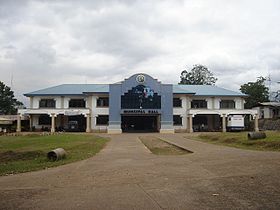
Lantapan
Appearance
| Lantapan | |
|---|---|
| Baley na Filipinas | |
 | |
 Lokasyon na Lantapan | |
 | |
| 8°0′0″N 125°1′24″E | |
| Dalin | Filipinas |
| Angipaletnegan | Hunyo 18, 1968 |
| Barangay | 14 |
| Kaawang[1] | |
| • Katiponan | 328.35 km2 (126.78 sq mi) |
| Elebasyon | 961 m (3,153 ft) |
| Bilang na too (Mayo 1, 2020)[2] | |
| • Katiponan | 65,974 |
| • Densidad | 200/km2 (520/sq mi) |
| Economia | |
| • Clase | unaan ya klase ya baley |
| • Ingresos | ₱241,452,760.04 (2020) |
| • Activos | ₱814,578,463.01 (2020) |
| • Pasivos | ₱255,427,361.49 (2020) |
| • Gastos | ₱206,330,550.98 (2020) |
| Kodigo na postal | 8722 |
| Kodigo na lugar | 88 |
| Website |
www |
Say Lantapan et unaan ya klase ya baley ed luyag na Bukidnon, Filipinas. Unong ed 1 Mayo 2020 census, say populasyon to et 65,974 totoo tan 14,653 abong. Walay kabaleg tan sukat to ya 328.35 sq. km. Say zip code to et 8722.
Saray barangay
[dumaen | dumaen so pinanlapuan]- Alanib
- Baclayon
- Balila
- Bantuanon
- Basak
- Bugcaon
- Ka-atoan (Kaatuan)
- Capitan Juan
- Cawayan
- Kulasihan
- Kibangay
- Poblacion
- Songco
- Victory
Demograpiko
[dumaen | dumaen so pinanlapuan]| Taon | Pop. | ±% p.a. |
|---|---|---|
| 1970 | 14,523 | — |
| 1975 | 20,006 | +6.63% |
| 1980 | 22,678 | +2.54% |
| 1990 | 33,581 | +4.00% |
| 1995 | 36,943 | +1.80% |
| 2000 | 42,383 | +2.99% |
| 2007 | 51,406 | +2.70% |
| 2010 | 55,934 | +3.12% |
| 2015 | 61,776 | +1.91% |
| 2020 | 65,974 | +1.30% |
| Reperensiya: Philippine Statistics Authority[3][4][5] | ||
Saray reperensiya
[dumaen | dumaen so pinanlapuan]- ↑ Error: Unable to display the reference properly. See the documentation for details.
- ↑ "2020 Census of Population and Housing (2020 CPH) Population Counts Declared Official by the President". Hulyo 7, 2021. https://psa.gov.ph/content/2020-census-population-and-housing-2020-cph-population-counts-declared-official-president.
- ↑ Census of Population (2015). "Region X (Northern Mindanao)". Total Population by Province, City, Municipality and Barangay. PSA. Retrieved 29 June 2016.
- ↑ Census of Population and Housing (2010). "Region X (Northern Mindanao)". Total Population by Province, City, Municipality and Barangay. NSO. Retrieved 29 June 2016.
- ↑ Censuses of Population (1903–2007). "Region X (Northern Mindanao)". Table 1. Population Enumerated in Various Censuses by Province/Highly Urbanized City: 1903 to 2007. NSO.
