Malaybalay
Appearance
| Malaybalay | |
|---|---|
| Siyudad | |
 | |
 Lokasyon na Malaybalay | |
 | |
| 8°9′23″N 125°8′0″E | |
| Dalin | Filipinas |
| Angipaletnegan | Hunyo 15, 1877 |
| Barangay | 46 |
| Kaawang[1] | |
| • Katiponan | 969.19 km2 (374.21 sq mi) |
| Elebasyon | 828 m (2,717 ft) |
| Bilang na too (Mayo 1, 2020)[2] | |
| • Katiponan | 190,712 |
| • Densidad | 200/km2 (510/sq mi) |
| Economia | |
| • Clase | unaan ya klase a siyudad |
| • Ingresos | ₱1,815,650,587.51 (2020) |
| • Activos | ₱4,578,586,773.18 (2020) |
| • Pasivos | ₱808,462,304.76 (2020) |
| • Gastos | ₱1,461,356,409.07 (2020) |
| Kodigo na postal | 8700 |
| Kodigo na lugar | 88 |
| Website |
malaybalaycity |
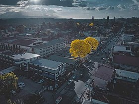
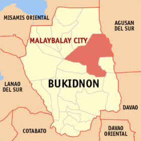
Say Malaybalay et unaan ya klase a siyudad ed luyag na Bukidnon, Filipinas. Unong ed 1 Mayo 2020 census, say populasyon to et 190,712 totoo tan 43,839 abong. Walay kabaleg tan sukat to ya 969.19 sq. km. Say zip code to et 8700.
Saray barangay
[dumaen | dumaen so pinanlapuan]- Aglayan
- Bangcud
- Busdi
- Cabangahan
- Caburacanan
- Canayan
- Capitan Angel
- Casisang
- Dalwangan
- Imbayao
- Indalaza
- Kalasungay
- Kabalabag
- Kulaman
- Laguitas
- Patpat (Lapu-lapu)
- Linabo
- Apo Macote
- Miglamin
- Magsaysay
- Maligaya
- Managok
- Manalog
- Mapayag
- Mapulo
- Barangay 1 (Pob.)
- Barangay 2 (Pob.)
- Barangay 3 (Pob.)
- Barangay 4 (Pob.)
- Barangay 5 (Pob.)
- Barangay 6 (Pob.)
- Barangay 7 (Pob.)
- Barangay 8 (Pob.)
- Barangay 9 (Pob.)
- Barangay 10 (Pob.)
- Barangay 11 (Pob.)
- Saint Peter
- San Jose
- San Martin
- Santo Niño
- Silae
- Simaya
- Sinanglanan
- Sumpong
- Violeta
- Zamboanguita
Demograpiko
[dumaen | dumaen so pinanlapuan]| Taon | Pop. | ±% p.a. |
|---|---|---|
| 1918 | 16,428 | — |
| 1939 | 18,816 | +0.65% |
| 1948 | 16,458 | −1.48% |
| 1960 | 32,522 | +5.84% |
| 1970 | 47,074 | +3.76% |
| 1975 | 65,198 | +6.75% |
| 1980 | 60,779 | −1.39% |
| 1990 | 94,722 | +4.54% |
| 1995 | 112,277 | +3.24% |
| 2000 | 123,672 | +2.09% |
| 2007 | 144,065 | +2.13% |
| 2010 | 153,085 | +2.23% |
| 2015 | 174,625 | +2.54% |
| 2020 | 190,712 | +1.75% |
| Reperensiya: Philippine Statistics Authority[3][4][5] | ||
Saray reperensiya
[dumaen | dumaen so pinanlapuan]- ↑ Error: Unable to display the reference properly. See the documentation for details.
- ↑ "2020 Census of Population and Housing (2020 CPH) Population Counts Declared Official by the President". Hulyo 7, 2021. https://psa.gov.ph/content/2020-census-population-and-housing-2020-cph-population-counts-declared-official-president.
- ↑ Census of Population (2015). "Region X (Northern Mindanao)". Total Population by Province, City, Municipality and Barangay. PSA. Retrieved 29 June 2016.
- ↑ Census of Population and Housing (2010). "Region X (Northern Mindanao)". Total Population by Province, City, Municipality and Barangay. NSO. Retrieved 29 June 2016.
- ↑ Censuses of Population (1903–2007). "Region X (Northern Mindanao)". Table 1. Population Enumerated in Various Censuses by Province/Highly Urbanized City: 1903 to 2007. NSO.
