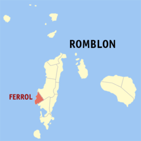
Ferrol
Appearance
Page Module:Infobox/styles.css has no content.
| Ferrol | |
|---|---|
| Baley na Filipinas | |
 | |
 Lokasyon na Ferrol | |
 | |
| 12°20′18″N 121°56′19″E | |
| Dalin | Filipinas |
| Angipaletnegan | 1850 |
| Barangay | 6 |
| Kaawang | |
| • Katiponan | 26.72 km2 (10.32 sq mi) |
| Elebasyon | 31 m (102 ft) |
| Bilang na too (Mayo 1, 2020)[1] | |
| • Katiponan | 8,005 |
| • Densidad | 300/km2 (780/sq mi) |
| Economia | |
| • Clase | kumanem ya klase ya baley |
| • Ingresos | ₱57,087,157.3624,532,465.0027,547,335.6630,946,351.3735,066,678.0038,578,893.0043,150,768.0046,834,741.0053,221,618.2461,530,081.8484,996,501.85 (2020) |
| • Activos | ₱199,373,817.3338,440,576.0055,919,378.1983,999,262.68129,151,607.00155,323,146.00150,626,226.00173,385,679.00186,103,907.39195,955,568.62216,852,528.95 (2020) |
| • Pasivos | ₱24,179,664.9714,677,749.0027,609,227.3249,515,546.8868,901,282.0081,809,566.0086,396,269.0069,145,833.0022,007,235.7415,965,027.1120,328,655.49 (2020) |
| • Gastos | ₱49,792,515.1922,555,756.0023,344,713.4524,345,847.0427,794,285.0025,213,708.0032,877,280.0034,850,414.0043,381,878.5354,599,301.1766,800,050.26 (2020) |
| Kodigo na postal | 5506 |
| Kodigo na lugar | 42 |
Say Ferrol et kumanem ya klase ya baley ed luyag na Romblon, Filipinas. Unong ed 1 Mayo 2020 census, say populasyon to et 8,005 totoo tan 1,999 abong. Walay kabaleg tan sukat to ya 26.72 sq. km. Say zip code to et 5506.
Saray barangay
[dumaen | dumaen so pinanlapuan]- Agnonoc
- Bunsoran
- Claro D. Recto
- Poblacion (corrugna)
- Hinaguman
- Tubigon
Demograpiko
[dumaen | dumaen so pinanlapuan]| Taon | Pop. | ±% p.a. |
|---|---|---|
| 1980 | 4,840 | — |
| 1990 | 5,621 | +1.51% |
| 1995 | 5,772 | +0.50% |
| 2000 | 5,924 | +0.56% |
| 2007 | 6,395 | +1.06% |
| 2010 | 6,802 | +2.27% |
| 2015 | 6,964 | +0.45% |
| 2020 | 8,005 | +2.78% |
| Reperensiya: Philippine Statistics Authority[2][3][4] | ||
Saray reperensiya
[dumaen | dumaen so pinanlapuan]- ↑ "2020 Census of Population and Housing (2020 CPH) Population Counts Declared Official by the President". Hulyo 7, 2021. https://psa.gov.ph/content/2020-census-population-and-housing-2020-cph-population-counts-declared-official-president.
- ↑ Census of Population (2015). "Region IV-B (Mimaropa)". Total Population by Province, City, Municipality and Barangay. PSA. Retrieved 29 June 2016.
- ↑ Census of Population and Housing (2010). "Region IV-B (Mimaropa)". Total Population by Province, City, Municipality and Barangay. NSO. Retrieved 29 June 2016.
- ↑ Censuses of Population (1903–2007). "Region IV-B (Mimaropa)". Table 1. Population Enumerated in Various Censuses by Province/Highly Urbanized City: 1903 to 2007. NSO.
Saray gawing ed labas
[dumaen | dumaen so pinanlapuan]
