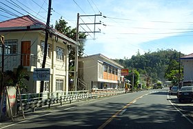
San Esteban
Appearance
Page Module:Infobox/styles.css has no content.
| San Esteban | |
|---|---|
| Baley na Filipinas | |
 | |
 Lokasyon na San Esteban | |
 | |
| 17°19′56″N 120°26′43″E | |
| Dalin | Filipinas |
| Barangay | 10 |
| Kaawang | |
| • Katiponan | 19.62 km2 (7.58 sq mi) |
| Elebasyon | 30 m (100 ft) |
| Bilang na too (Mayo 1, 2020)[1] | |
| • Katiponan | 8,381 |
| • Densidad | 430/km2 (1,100/sq mi) |
| Economia | |
| • Clase | kumalima ya klase ya baley |
| • Ingresos | ₱209,247,463.3153,915,163.9053,019,417.6733,295,782.1939,125,568.40147,326,826.64301,823,679.03132,262,139.92510,044,969.45515,074,033.23 (2020) |
| • Activos | ₱822,253,717.89118,792,286.34118,298,785.5394,669,233.39109,644,227.47359,042,404.69615,892,583.73653,892,885.67722,470,253.881,202,426,423.411,570,932,475.13 (2020) |
| • Pasivos | ₱58,591,251.4532,476,830.0325,376,317.8214,226,780.8931,696,878.9823,641,998.8523,230,913.9465,399,592.0330,772,707.5961,888,522.53 (2020) |
| • Gastos | ₱101,244,708.7729,301,278.9031,741,070.1733,900,870.6836,286,861.4965,039,181.1944,567,315.2286,002,967.0268,385,056.13101,306,927.88175,579,311.31 (2020) |
| Kodigo na postal | 2706 |
| Kodigo na lugar | 77 |
Say San Esteban et kumalima ya klase ya baley ed luyag na Ilocos ed Abalaten, Filipinas. Unong ed 1 Mayo 2020 census, say populasyon to et 8,381 totoo tan 2,150 abong. Walay kabaleg tan sukat to ya 19.62 sq. km. Say zip code to et 2706.
Saray barangay
[dumaen | dumaen so pinanlapuan]- Ansad
- Apatot
- Bacteria
- Cabaroan
- Cappa-Cappa
- Poblacion
- San Nicolas
- San Pablo
- San Rafael
- Villa Quirino
Demograpiko
[dumaen | dumaen so pinanlapuan]| Taon | Pop. | ±% p.a. |
|---|---|---|
| 1903 | 2,421 | — |
| 1918 | 3,372 | +2.23% |
| 1939 | 3,363 | −0.01% |
| 1948 | 3,617 | +0.81% |
| 1960 | 4,269 | +1.39% |
| 1970 | 4,848 | +1.28% |
| 1975 | 5,275 | +1.71% |
| 1980 | 5,504 | +0.85% |
| 1990 | 6,327 | +1.40% |
| 1995 | 6,508 | +0.53% |
| 2000 | 7,174 | +2.11% |
| 2007 | 7,779 | +1.12% |
| 2010 | 8,072 | +1.35% |
| 2015 | 8,349 | +0.64% |
| 2020 | 8,381 | +0.08% |
| Reperensiya: Philippine Statistics Authority[2][3][4] | ||
Saray reperensiya
[dumaen | dumaen so pinanlapuan]- ↑ "2020 Census of Population and Housing (2020 CPH) Population Counts Declared Official by the President". Hulyo 7, 2021. https://psa.gov.ph/content/2020-census-population-and-housing-2020-cph-population-counts-declared-official-president.
- ↑ Census of Population (2015). "Region I (Ilocos Region)". Total Population by Province, City, Municipality and Barangay. PSA. Retrieved 29 June 2016.
- ↑ Census of Population and Housing (2010). "Region I (Ilocos Region)". Total Population by Province, City, Municipality and Barangay. NSO. Retrieved 29 June 2016.
- ↑ Censuses of Population (1903–2007). "Region I (Ilocos Region)". Table 1. Population Enumerated in Various Censuses by Province/Highly Urbanized City: 1903 to 2007. NSO.
