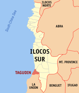
Tagudin
Appearance
Page Module:Infobox/styles.css has no content.
| Tagudin | |
|---|---|
| Baley na Filipinas | |
 | |
 Lokasyon na Tagudin | |
 | |
| 16°56′10″N 120°26′47″E | |
| Dalin | Filipinas |
| Barangay | 43 |
| Kaawang | |
| • Katiponan | 151.19 km2 (58.37 sq mi) |
| Elebasyon | 30 m (100 ft) |
| Bilang na too (Mayo 1, 2020)[1] | |
| • Katiponan | 41,538 |
| • Densidad | 270/km2 (710/sq mi) |
| Economia | |
| • Clase | kumadua ya klase ya baley |
| • Ingresos | ₱169,697,396.72100,785,092.78107,590,092.6497,605,303.57135,877,417.34195,142,804.63136,606,223.71341,840,744.84325,421,311.81508,056,224.00422,794,392.36 (2020) |
| • Activos | ₱863,878,668.86149,419,680.26187,227,594.92160,995,519.14183,716,573.34343,926,169.47349,006,500.44493,092,003.54688,196,789.731,068,000,306.131,203,241,142.69 (2020) |
| • Pasivos | ₱171,325,569.8042,317,783.3072,672,529.4947,207,781.7238,472,769.0352,639,441.7257,856,750.2350,661,638.9099,338,023.8990,597,637.13109,041,659.23 (2020) |
| • Gastos | ₱216,477,445.0794,506,232.5499,537,298.7594,971,746.58107,962,619.90113,873,221.17138,814,259.61176,367,531.27190,179,057.70243,566,526.54334,671,092.88 (2020) |
| Kodigo na postal | 2714 |
| Kodigo na lugar | 77 |
| Website | www |
Say Tagudin et kumadua ya klase ya baley ed luyag na Ilocos ed Abalaten, Filipinas. Unong ed 1 Mayo 2020 census, say populasyon to et 41,538 totoo tan 9,992 abong. Walay kabaleg tan sukat to ya 151.19 sq. km. Say zip code to et 2714.
Saray barangay
[dumaen | dumaen so pinanlapuan]- Ag-aguman
- Ambalayat
- Baracbac
- Bario-an
- Baritao
- Becques
- Bimmanga
- Bio
- Bitalag
- Borono
- Bucao East
- Bucao West
- Cabaroan
- Cabugbugan
- Cabulanglangan
- Dacutan
- Dardarat
- Del Pilar
- Farola
- Gabur
- Garitan
- Jardin
- Lacong
- Lantag
- Las-ud
- Libtong
- Lubnac
- Magsaysay
- Malacañang
- Pacac
- Pallogan
- Pula
- Pudoc East
- Pudoc West
- Quirino
- Ranget
- Rizal
- Salvacion
- San Miguel
- Sawat
- Tallaoen
- Tampugo
- Tarangotong
Demograpiko
[dumaen | dumaen so pinanlapuan]| Taon | Pop. | ±% p.a. |
|---|---|---|
| 1903 | 8,503 | — |
| 1918 | 11,237 | +1.88% |
| 1939 | 13,115 | +0.74% |
| 1948 | 15,637 | +1.97% |
| 1960 | 18,191 | +1.27% |
| 1970 | 19,575 | +0.74% |
| 1975 | 22,887 | +3.18% |
| 1980 | 23,432 | +0.47% |
| 1990 | 29,295 | +2.26% |
| 1995 | 30,697 | +0.88% |
| 2000 | 34,427 | +2.49% |
| 2007 | 35,791 | +0.54% |
| 2010 | 38,122 | +2.32% |
| 2015 | 39,277 | +0.57% |
| 2020 | 41,538 | +1.11% |
| Reperensiya: Philippine Statistics Authority[2][3][4] | ||
Saray reperensiya
[dumaen | dumaen so pinanlapuan]- ↑ "2020 Census of Population and Housing (2020 CPH) Population Counts Declared Official by the President". Hulyo 7, 2021. https://psa.gov.ph/content/2020-census-population-and-housing-2020-cph-population-counts-declared-official-president.
- ↑ Census of Population (2015). "Region I (Ilocos Region)". Total Population by Province, City, Municipality and Barangay. PSA. Retrieved 29 June 2016.
- ↑ Census of Population and Housing (2010). "Region I (Ilocos Region)". Total Population by Province, City, Municipality and Barangay. NSO. Retrieved 29 June 2016.
- ↑ Censuses of Population (1903–2007). "Region I (Ilocos Region)". Table 1. Population Enumerated in Various Censuses by Province/Highly Urbanized City: 1903 to 2007. NSO.
