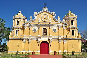
San Vicente, Ilocos Sur
Appearance
Page Module:Infobox/styles.css has no content.
| San Vicente | |
|---|---|
| Baley na Filipinas | |
 | |
 Lokasyon na San Vicente | |
 | |
| 17°35′41″N 120°22′31″E | |
| Dalin | Filipinas |
| Barangay | 7 |
| Kaawang | |
| • Katiponan | 12.60 km2 (4.86 sq mi) |
| Elebasyon | 7 m (23 ft) |
| Bilang na too (Mayo 1, 2020)[1] | |
| • Katiponan | 13,118 |
| • Densidad | 1,000/km2 (2,700/sq mi) |
| Economia | |
| • Clase | kumalima ya klase ya baley |
| • Ingresos | ₱118,920,234.3627,081,732.2748,571,445.7437,727,387.9543,486,446.0383,006,500.7653,139,487.10107,289,923.98142,706,241.96195,595,712.68 (2020) |
| • Activos | ₱199,437,547.3372,997,355.5560,081,289.3566,867,456.1468,348,365.8178,228,093.4781,919,135.92113,546,187.12156,744,412.31277,046,772.67385,381,981.40 (2020) |
| • Pasivos | ₱23,139,200.874,495,976.596,416,105.778,162,811.1514,006,652.5619,601,459.3220,040,415.0123,587,109.5418,530,019.8430,748,330.4128,437,502.94 (2020) |
| • Gastos | ₱67,415,198.4929,096,107.1932,235,524.8232,687,121.5436,248,809.5440,470,508.4244,221,402.3952,268,089.4655,571,076.0568,154,556.1383,374,281.15 (2020) |
| Kodigo na postal | 2726 |
| Kodigo na lugar | 77 |
Say San Vicente et kumalima ya klase ya baley ed luyag na Ilocos ed Abalaten, Filipinas. Unong ed 1 Mayo 2020 census, say populasyon to et 13,118 totoo tan 3,229 abong. Walay kabaleg tan sukat to ya 12.60 sq. km. Say zip code to et 2726.
Saray barangay
[dumaen | dumaen so pinanlapuan]- Bantaoay
- Bayubay Norte
- Bayubay Sur
- Lubong
- Poblacion
- Pudoc
- San Sebastian
Demograpiko
[dumaen | dumaen so pinanlapuan]| Taon | Pop. | ±% p.a. |
|---|---|---|
| 1903 | 5,060 | — |
| 1918 | 5,858 | +0.98% |
| 1939 | 6,163 | +0.24% |
| 1948 | 6,151 | −0.02% |
| 1960 | 7,094 | +1.20% |
| 1970 | 7,539 | +0.61% |
| 1975 | 8,299 | +1.94% |
| 1980 | 8,488 | +0.45% |
| 1990 | 9,989 | +1.64% |
| 1995 | 9,848 | −0.27% |
| 2000 | 10,877 | +2.15% |
| 2007 | 11,907 | +1.26% |
| 2010 | 11,720 | −0.57% |
| 2015 | 12,758 | +1.63% |
| 2020 | 13,118 | +0.55% |
| Reperensiya: Philippine Statistics Authority[2][3][4] | ||
Saray reperensiya
[dumaen | dumaen so pinanlapuan]- ↑ "2020 Census of Population and Housing (2020 CPH) Population Counts Declared Official by the President". Hulyo 7, 2021. https://psa.gov.ph/content/2020-census-population-and-housing-2020-cph-population-counts-declared-official-president.
- ↑ Census of Population (2015). "Region I (Ilocos Region)". Total Population by Province, City, Municipality and Barangay. PSA. Retrieved 29 June 2016.
- ↑ Census of Population and Housing (2010). "Region I (Ilocos Region)". Total Population by Province, City, Municipality and Barangay. NSO. Retrieved 29 June 2016.
- ↑ Censuses of Population (1903–2007). "Region I (Ilocos Region)". Table 1. Population Enumerated in Various Censuses by Province/Highly Urbanized City: 1903 to 2007. NSO.
