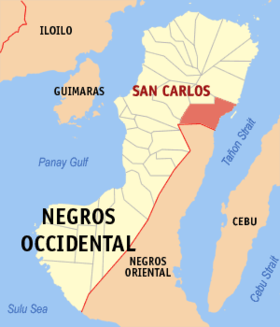
San Carlos, Negros Occidental
Appearance
| San Carlos | |
|---|---|
| Siyudad | |
 | |
 Lokasyon na San Carlos | |
 | |
| 10°29′35″N 123°24′34″E | |
| Dalin | Filipinas |
| Angipaletnegan | 1898 |
| Barangay | 18 |
| Kaawang | |
| • Katiponan | 451.50 km2 (174.33 sq mi) |
| Elebasyon | 456 m (1,496 ft) |
| Bilang na too (Mayo 1, 2020)[1] | |
| • Katiponan | 132,650 |
| • Densidad | 290/km2 (760/sq mi) |
| Economia | |
| • Clase | kumadua ya klase a siyudad |
| • Ingresos | ₱1,283,219,777.38578,993,264.13627,292,925.20672,487,895.79819,244,077.94862,982,961.30956,972,766.121,104,676,142.441,209,891,170.651,719,107,093.042,147,835,769.66 (2020) |
| • Activos | ₱4,078,619,421.851,134,435,269.151,185,969,678.581,205,372,063.571,790,272,626.022,373,892,783.332,737,973,766.923,242,536,594.013,652,958,506.194,412,455,423.864,914,556,336.11 (2020) |
| • Pasivos | ₱786,625,087.24283,633,306.62319,399,164.57322,373,403.90464,650,063.00483,324,722.09527,998,267.05628,857,677.95701,868,969.86837,635,423.51849,570,607.14 (2020) |
| • Gastos | ₱1,127,273,280.91462,501,486.28495,433,251.55518,823,887.11535,859,741.52547,872,642.43621,210,897.18680,861,007.27819,575,727.101,415,004,252.921,628,239,796.42 (2020) |
| Kodigo na postal | 6127 |
| Kodigo na lugar | 34 |
| Website |
www |
Say San Carlos et kumadua ya klase a siyudad ed luyag na Negros ed Sagor, Filipinas. Unong ed 1 Mayo 2020 census, say populasyon to et 132,650 totoo tan 33,623 abong. Walay kabaleg tan sukat to ya 451.50 sq. km. Say zip code to et 6127.
Saray barangay
[dumaen | dumaen so pinanlapuan]- Bagonbon
- Buluangan
- Codcod
- Ermita
- Guadalupe
- Nataban
- Palampas
- Barangay I (Pob.)
- Barangay II (Pob.)
- Barangay III (Pob.)
- Barangay IV (Pob.)
- Barangay V (Pob.)
- Barangay VI (Pob.)
- Prosperidad
- Punao
- Quezon
- Rizal
- San Juan
Demograpiko
[dumaen | dumaen so pinanlapuan]| Taon | Pop. | ±% p.a. |
|---|---|---|
| 1903 | 9,749 | — |
| 1918 | 42,453 | +10.31% |
| 1939 | 69,990 | +2.41% |
| 1948 | 92,250 | +3.12% |
| 1960 | 124,756 | +2.55% |
| 1970 | 90,058 | −3.20% |
| 1975 | 90,982 | +0.20% |
| 1980 | 91,627 | +0.14% |
| 1990 | 105,713 | +1.44% |
| 1995 | 101,429 | −0.77% |
| 2000 | 118,259 | +3.35% |
| 2007 | 129,809 | +1.29% |
| 2010 | 129,981 | +0.05% |
| 2015 | 132,536 | +0.37% |
| 2020 | 132,650 | +0.02% |
| Reperensiya: Philippine Statistics Authority[2][3][4] | ||
Saray reperensiya
[dumaen | dumaen so pinanlapuan]- ↑ "2020 Census of Population and Housing (2020 CPH) Population Counts Declared Official by the President". Hulyo 7, 2021. https://psa.gov.ph/content/2020-census-population-and-housing-2020-cph-population-counts-declared-official-president.
- ↑ Census of Population (2015). "Region VI (Western Visayas)". Total Population by Province, City, Municipality and Barangay. PSA. Retrieved 29 June 2016.
- ↑ Census of Population and Housing (2010). "Region VI (Western Visayas)". Total Population by Province, City, Municipality and Barangay. NSO. Retrieved 29 June 2016.
- ↑ Censuses of Population (1903–2007). "Region VI (Western Visayas)". Table 1. Population Enumerated in Various Censuses by Province/Highly Urbanized City: 1903 to 2007. NSO.
