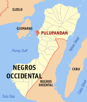
Pulupandan
Appearance
Page Module:Infobox/styles.css has no content.
| Pulupandan | |
|---|---|
| Baley na Filipinas | |
 Lokasyon na Pulupandan | |
 | |
| 10°31′12″N 122°48′0″E | |
| Dalin | Filipinas |
| Barangay | 20 |
| Kaawang | |
| • Katiponan | 23.00 km2 (8.88 sq mi) |
| Elebasyon | 2 m (7 ft) |
| Bilang na too (Mayo 1, 2020)[1] | |
| • Katiponan | 30,117 |
| • Densidad | 1,300/km2 (3,400/sq mi) |
| Economia | |
| • Clase | kumatlo ya klase ya baley |
| • Ingresos | ₱108,319,831.3962,036,863.7960,437,524.2559,007,856.6673,199,421.4672,683,796.8282,538,707.2891,565,465.94100,656,257.80116,099,079.21155,411,742.74 (2020) |
| • Activos | ₱274,058,324.08106,527,557.87109,875,626.98121,508,175.06171,449,415.95206,643,114.13274,019,625.16305,718,941.33286,273,589.80277,368,966.43312,999,301.16 (2020) |
| • Pasivos | ₱198,673,946.9645,443,245.1148,263,254.9160,751,188.43105,060,940.47137,918,181.98195,697,618.13223,359,737.09212,065,841.89200,075,177.58219,747,874.88 (2020) |
| • Gastos | ₱102,266,282.5953,690,285.1558,679,523.4559,863,242.1067,557,932.6167,431,587.7672,589,694.1485,285,095.7397,858,812.86113,397,477.97139,439,105.31 (2020) |
| Kodigo na postal | 6102 |
| Kodigo na lugar | 34 |
Say Pulupandan et kumatlo ya klase ya baley ed luyag na Negros ed Sagor, Filipinas. Unong ed 1 Mayo 2020 census, say populasyon to et 30,117 totoo tan 7,701 abong. Walay kabaleg tan sukat to ya 23.00 sq. km. Say zip code to et 6102.
Saray barangay
[dumaen | dumaen so pinanlapuan]- Barangay Zone 1-A (Pob. / Paco beach)
- Barangay Zone 4-A (Poblacion)
- Barangay Zone 1 (Pob. / Green beach)
- Barangay Zone 2 (Poblacion)
- Barangay Zone 3 (Poblacion)
- Barangay Zone 4 (Poblacion)
- Barangay Zone 5 (Poblacion)
- Barangay Zone 6 (Poblacion)
- Barangay Zone 7 (Poblacion)
- Canjusa
- Crossing Pulupandan
- Culo
- Mabini
- Pag-ayon
- Palaka Norte
- Palaka Sur
- Patic
- Tapong
- Ubay
- Utod
Demograpiko
[dumaen | dumaen so pinanlapuan]| Taon | Pop. | ±% p.a. |
|---|---|---|
| 1903 | 6,167 | — |
| 1918 | 5,268 | −1.04% |
| 1939 | 10,751 | +3.46% |
| 1948 | 11,726 | +0.97% |
| 1960 | 14,844 | +1.98% |
| 1970 | 19,476 | +2.75% |
| 1975 | 23,665 | +3.98% |
| 1980 | 24,824 | +0.96% |
| 1990 | 22,983 | −0.77% |
| 1995 | 24,932 | +1.54% |
| 2000 | 25,849 | +0.78% |
| 2007 | 27,072 | +0.64% |
| 2010 | 25,350 | −2.36% |
| 2015 | 27,735 | +1.73% |
| 2020 | 30,117 | +1.63% |
| Reperensiya: Philippine Statistics Authority[2][3][4] | ||
Saray reperensiya
[dumaen | dumaen so pinanlapuan]- ↑ "2020 Census of Population and Housing (2020 CPH) Population Counts Declared Official by the President". Hulyo 7, 2021. https://psa.gov.ph/content/2020-census-population-and-housing-2020-cph-population-counts-declared-official-president.
- ↑ Census of Population (2015). "Region VI (Western Visayas)". Total Population by Province, City, Municipality and Barangay. PSA. Retrieved 29 June 2016.
- ↑ Census of Population and Housing (2010). "Region VI (Western Visayas)". Total Population by Province, City, Municipality and Barangay. NSO. Retrieved 29 June 2016.
- ↑ Censuses of Population (1903–2007). "Region VI (Western Visayas)". Table 1. Population Enumerated in Various Censuses by Province/Highly Urbanized City: 1903 to 2007. NSO.
