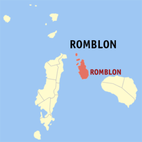
Romblon, Romblon
Appearance
| Romblon | |
|---|---|
| Baley na Filipinas | |
 | |
 Lokasyon na Romblon | |
 | |
| 12°34′44″N 122°16′29″E | |
| Dalin | Filipinas |
| Barangay | 31 |
| Kaawang | |
| • Katiponan | 86.87 km2 (33.54 sq mi) |
| Elebasyon | 43 m (141 ft) |
| Bilang na too (Mayo 1, 2020)[1] | |
| • Katiponan | 40,554 |
| • Densidad | 470/km2 (1,200/sq mi) |
| Economia | |
| • Clase | kumatlo ya klase ya baley |
| • Ingresos | ₱144,141,795.2666,692,548.0071,498,959.2781,185,400.80101,582,478.00109,405,964.00111,938,180.00120,491,279.00107,100,320.64 (2020) |
| • Activos | ₱231,838,550.9159,710,506.0054,344,921.5463,453,507.2877,756,714.00107,004,703.00155,916,507.00200,882,063.00223,820,234.96 (2020) |
| • Pasivos | ₱32,126,697.1239,076,085.0031,207,904.1327,507,166.9832,984,707.0050,056,886.0056,058,348.0054,897,950.0062,838,107.43 (2020) |
| • Gastos | ₱106,025,909.3161,347,406.0058,251,092.5365,160,037.7686,035,543.0092,558,967.00 (2020) |
| Kodigo na postal | 5500 |
| Kodigo na lugar | 42 |
| Website |
www |
Say Romblon et kumatlo ya klase ya baley ed luyag na Romblon, Filipinas. Unong ed 1 Mayo 2020 census, say populasyon to et 40,554 totoo tan 10,406 abong. Walay kabaleg tan sukat to ya 86.87 sq. km. Say zip code to et 5500.
Saray barangay
[dumaen | dumaen so pinanlapuan]- Agbaluto
- Agpanabat
- Agbudia
- Agnaga
- Agnay
- Agnipa
- Agtongo
- Alad
- Bagacay
- Cajimos
- Calabogo
- Capaclan
- Ginablan
- Guimpingan
- Ilauran
- Lamao
- Li-o
- Logbon
- Lunas
- Lonos
- Macalas
- Mapula
- Cobrador (Naguso)
- Palje
- Barangay I (Pob.)
- Barangay II (Pob.)
- Barangay III (Pob.)
- Barangay IV (Pob.)
- Sablayan
- Sawang
- Tambac
Demograpiko
[dumaen | dumaen so pinanlapuan]| Taon | Pop. | ±% p.a. |
|---|---|---|
| 1903 | 10,095 | — |
| 1918 | 10,467 | +0.24% |
| 1939 | 14,309 | +1.50% |
| 1948 | 12,879 | −1.16% |
| 1960 | 16,708 | +2.19% |
| 1970 | 21,717 | +2.65% |
| 1975 | 22,489 | +0.70% |
| 1980 | 24,251 | +1.52% |
| 1990 | 29,983 | +2.14% |
| 1995 | 34,290 | +2.55% |
| 2000 | 36,612 | +1.41% |
| 2007 | 37,544 | +0.35% |
| 2010 | 37,995 | +0.44% |
| 2015 | 38,758 | +0.38% |
| 2020 | 40,554 | +0.89% |
| Reperensiya: Philippine Statistics Authority[2][3][4] | ||
Saray reperensiya
[dumaen | dumaen so pinanlapuan]- ↑ "2020 Census of Population and Housing (2020 CPH) Population Counts Declared Official by the President". Hulyo 7, 2021. https://psa.gov.ph/content/2020-census-population-and-housing-2020-cph-population-counts-declared-official-president.
- ↑ Census of Population (2015). "Region IV-B (Mimaropa)". Total Population by Province, City, Municipality and Barangay. PSA. Retrieved 29 June 2016.
- ↑ Census of Population and Housing (2010). "Region IV-B (Mimaropa)". Total Population by Province, City, Municipality and Barangay. NSO. Retrieved 29 June 2016.
- ↑ Censuses of Population (1903–2007). "Region IV-B (Mimaropa)". Table 1. Population Enumerated in Various Censuses by Province/Highly Urbanized City: 1903 to 2007. NSO.
Saray gawing ed labas
[dumaen | dumaen so pinanlapuan]- PhilAtlas.com
- Philippine Standard Geographic Code
- Local Governance Performance Management System
- www
.romblon .gov .ph
