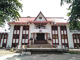
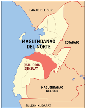
Datu Odin Sinsuat
Appearance
| Datu Odin Sinsuat | |
|---|---|
| Baley na Filipinas | |
 | |
 Lokasyon na Datu Odin Sinsuat | |
 | |
| 7°11′20″N 124°11′2″E | |
| Dalin | Filipinas |
| Barangay | 34 |
| Kaawang | |
| • Katiponan | 461.80 km2 (178.30 sq mi) |
| Elebasyon | 68 m (223 ft) |
| Bilang na too (Mayo 1, 2020)[1] | |
| • Katiponan | 116,768 |
| • Densidad | 250/km2 (650/sq mi) |
| Economia | |
| • Clase | kumadua ya klase ya baley |
| • Ingresos | ₱349,653,127.38168,383,730.89146,160,455.86203,531,003.01194,361,000.0077,258,894.97264,857,877.94272,430,088.01285,107,438.41341,308,316.82507,556,182.08 (2020) |
| • Activos | ₱164,728,433.2089,487,059.0935,968,078.3536,088,208.4117,602,000.00108,009,883.4072,453,672.84106,764,323.87151,431,334.25339,380,230.32490,376,403.10 (2020) |
| • Pasivos | ₱32,846,521.1646,447,574.8827,583,868.047,591,203.81509,000.0046,827,195.2150,857,451.6977,480,169.0039,228,023.7926,983,204.23107,655,005.18 (2020) |
| • Gastos | ₱329,724,919.11166,113,005.69209,391,671.65130,839,460.88194,423,000.0072,259,285.45262,654,774.54264,742,154.87280,004,609.24324,371,084.35455,180,034.24 (2020) |
| Kodigo na postal | 9601 |
| Kodigo na lugar | 64 |
| Website |
www |
Say Datu Odin Sinsuat et kumadua ya klase ya baley ed luyag na Maguindanao del Norte, Filipinas. Unong ed 1 Mayo 2020 census, say populasyon to et 116,768 totoo tan 20,284 abong. Walay kabaleg tan sukat to ya 461.80 sq. km. Say zip code to et 9601.
Saray barangay
[dumaen | dumaen so pinanlapuan]- Ambolodto
- Awang
- Badak
- Bagoenged
- Baka
- Benolen
- Bitu
- Bongued
- Bugawas
- Capiton
- Dados
- Dalican Poblacion
- Dinaig Proper
- Dulangan
- Kakar
- Kenebeka
- Kurintem
- Kusiong
- Labungan
- Linek
- Makir
- Margues
- Mompong
- Nekitan
- Sapalan
- Semba
- Sibuto
- Sifaren (Sifaran)
- Tambak
- Tamontaka
- Tanuel
- Tapian
- Taviran
- Tenonggos
Demograpiko
[dumaen | dumaen so pinanlapuan]| Taon | Pop. | ±% p.a. |
|---|---|---|
| 1918 | 6,565 | — |
| 1939 | 14,196 | +3.74% |
| 1948 | 56,439 | +16.57% |
| 1960 | 44,164 | −2.02% |
| 1970 | 42,827 | −0.31% |
| 1975 | 53,593 | +4.60% |
| 1980 | 48,353 | −2.04% |
| 1990 | 52,370 | +0.80% |
| 1995 | 59,841 | +2.53% |
| 2000 | 71,569 | +3.91% |
| 2007 | 103,765 | +5.26% |
| 2010 | 76,332 | −10.57% |
| 2015 | 99,210 | +5.12% |
| 2020 | 116,768 | +3.26% |
| Reperensiya: Philippine Statistics Authority[2][3][4] | ||
Saray reperensiya
[dumaen | dumaen so pinanlapuan]- ↑ "2020 Census of Population and Housing (2020 CPH) Population Counts Declared Official by the President". Hulyo 7, 2021. https://psa.gov.ph/content/2020-census-population-and-housing-2020-cph-population-counts-declared-official-president.
- ↑ Census of Population (2015). "ARMM – Autonomous Region in Muslim Mindanao". Total Population by Province, City, Municipality and Barangay. PSA. Retrieved 29 June 2016.
- ↑ Census of Population and Housing (2010). "ARMM – Autonomous Region in Muslim Mindanao". Total Population by Province, City, Municipality and Barangay. NSO. Retrieved 29 June 2016.
- ↑ Censuses of Population (1903–2007). "ARMM – Autonomous Region in Muslim Mindanao". Table 1. Population Enumerated in Various Censuses by Province/Highly Urbanized City: 1903 to 2007. NSO.
Saray gawing ed labas
[dumaen | dumaen so pinanlapuan]- PhilAtlas.com
- Philippine Standard Geographic Code
- Local Governance Performance Management System
- www
.datuodinsinsuat .gov .ph
