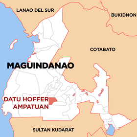
Datu Hoffer Ampatuan
Appearance
(Redirected from Datu Hoffer Ampatuan, Maguindanao)
| Datu Hoffer Ampatuan | |
|---|---|
| Baley na Filipinas | |
 Lokasyon na Datu Hoffer Ampatuan | |
 | |
| 6°51′29″N 124°25′31″E | |
| Dalin | Filipinas |
| Barangay | 11 |
| Kaawang | |
| • Katiponan | 461.10 km2 (178.03 sq mi) |
| Elebasyon | 132 m (433 ft) |
| Bilang na too (Mayo 1, 2020)[1] | |
| • Katiponan | 26,660 |
| • Densidad | 58/km2 (150/sq mi) |
| Economia | |
| • Ingresos | ₱97,229,000.00918,000.001,836,000.00840,763.3172,427,342.594,047,717.176,368,280.703,711,000.00104,014,882.44143,390,669.57 (2020) |
| • Activos | ₱79,446,000.0032,284,102.7464,568,205.4756,572,145.3030,338,058.9359,041,829.5056,937,537.4255,176,000.0089,145,710.08101,003,276.97 (2020) |
| • Pasivos | ₱1,147,000.000.0018,266.1439,000.00824,489.83957,107.76 (2020) |
| • Gastos | ₱90,674,000.001,385,047.392,770,094.781,897,487.5870,819,296.135,739,368.228,473,382.785,511,000.0093,164,655.17128,991,741.35 (2020) |
| Kodigo na postal | 9608 |
| Kodigo na lugar | 64 |
Say Datu Hoffer Ampatuan et no value ed luyag na Maguindanao del Sur, Filipinas. Unong ed 1 Mayo 2020 census, say populasyon to et 26,660 totoo tan 4,443 abong. Walay kabaleg tan sukat to ya 461.10 sq. km. Say zip code to et 9608.
Saray barangay
[dumaen | dumaen so pinanlapuan]- Kubentong
- Labu-labu I
- Labu-labu II
- Limpongo
- Macalag
- Sayap
- Taib
- Talibadok
- Tuayan
- Tuayan I
- Tuntungan
Demograpiko
[dumaen | dumaen so pinanlapuan]| Taon | Pop. | ±% p.a. |
|---|---|---|
| 2010 | 16,295 | — |
| 2015 | 25,012 | +8.50% |
| 2020 | 26,660 | +1.26% |
| Reperensiya: Philippine Statistics Authority[2][3][4] | ||
Saray reperensiya
[dumaen | dumaen so pinanlapuan]- ↑ "2020 Census of Population and Housing (2020 CPH) Population Counts Declared Official by the President". Hulyo 7, 2021. https://psa.gov.ph/content/2020-census-population-and-housing-2020-cph-population-counts-declared-official-president.
- ↑ Census of Population (2015). "ARMM – Autonomous Region in Muslim Mindanao". Total Population by Province, City, Municipality and Barangay. PSA. Retrieved 29 June 2016.
- ↑ Census of Population and Housing (2010). "ARMM – Autonomous Region in Muslim Mindanao". Total Population by Province, City, Municipality and Barangay. NSO. Retrieved 29 June 2016.
- ↑ Censuses of Population (1903–2007). "ARMM – Autonomous Region in Muslim Mindanao". Table 1. Population Enumerated in Various Censuses by Province/Highly Urbanized City: 1903 to 2007. NSO.
