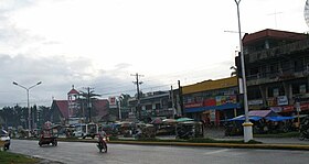
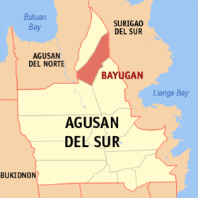
Bayugan
Appearance
Page Module:Infobox/styles.css has no content.
| Bayugan | ||
|---|---|---|
| Siyudad | ||
 | ||
| ||
 Lokasyon na Bayugan | ||
 | ||
| 8°42′36″N 125°45′0″E | ||
| Dalin | Filipinas | |
| Angipaletnegan | Agosto 20, 1961 | |
| Barangay | 43 | |
| Kaawang[1] | ||
| • Katiponan | 688.77 km2 (265.94 sq mi) | |
| Elebasyon | 270 m (890 ft) | |
| Bilang na too (Mayo 1, 2020)[2] | ||
| • Katiponan | 109,499 | |
| • Densidad | 160/km2 (410/sq mi) | |
| Economia | ||
| • Clase | kumalima ya klase a siyudad | |
| • Ingresos | ₱1,207,578,567.68 (2020) | |
| • Activos | ₱4,506,041,017.35 (2020) | |
| • Pasivos | ₱470,371,136.89 (2020) | |
| • Gastos | ₱739,959,677.66 (2020) | |
| Kodigo na postal | 8502 | |
| Kodigo na lugar | 85 | |
| Website | www | |
Say Bayugan et kumalima ya klase a siyudad ed luyag na Agusan ed Abalaten, Filipinas. Unong ed 1 Mayo 2020 census, say populasyon to et 109,499 totoo tan 26,259 abong. Walay kabaleg tan sukat to ya 688.77 sq. km. Say zip code to et 8502.
Saray barangay
[dumaen | dumaen so pinanlapuan]- Taglatawan
- Calaitan
- Charito
- Fili
- Hamogaway
- Katipunan
- Mabuhay
- Marcelina
- Maygatasan
- Noli
- Osmeña
- Panaytay
- Poblacion
- Sagmone
- Saguma
- Salvacion
- San Isidro
- Santa Irene
- Verdu
- Del Carmen
- Berseba
- Bucac
- Cagbas
- Canayugan
- Claro Cortez
- Gamao
- Getsemane
- Grace Estate
- Magkiangkang
- Mahayag
- Montivesta
- Mt. Ararat
- Mt. Carmel
- Mt. Olive
- New Salem
- Pinagalaan
- San Agustin
- San Juan
- Santa Teresita
- Santo Niño
- Taglibas
- Tagubay
- Villa Ondayon
Demograpiko
[dumaen | dumaen so pinanlapuan]| Taon | Pop. | ±% p.a. |
|---|---|---|
| 1970 | 37,816 | — |
| 1975 | 43,603 | +2.90% |
| 1980 | 56,367 | +5.27% |
| 1990 | 78,725 | +3.40% |
| 1995 | 89,999 | +2.54% |
| 2000 | 93,623 | +0.85% |
| 2007 | 95,032 | +0.21% |
| 2010 | 99,361 | +1.63% |
| 2015 | 103,202 | +0.72% |
| 2020 | 109,499 | +1.17% |
| Reperensiya: Philippine Statistics Authority[3][4][5] | ||
Saray reperensiya
[dumaen | dumaen so pinanlapuan]- ↑ Error: Unable to display the reference properly. See the documentation for details.
- ↑ "2020 Census of Population and Housing (2020 CPH) Population Counts Declared Official by the President". Hulyo 7, 2021. https://psa.gov.ph/content/2020-census-population-and-housing-2020-cph-population-counts-declared-official-president.
- ↑ Census of Population (2015). "Caraga". Total Population by Province, City, Municipality and Barangay. PSA. Retrieved 29 June 2016.
- ↑ Census of Population and Housing (2010). "Caraga". Total Population by Province, City, Municipality and Barangay. NSO. Retrieved 29 June 2016.
- ↑ Censuses of Population (1903–2007). "Caraga". Table 1. Population Enumerated in Various Censuses by Province/Highly Urbanized City: 1903 to 2007. NSO.
Saray gawing ed labas
[dumaen | dumaen so pinanlapuan]- PhilAtlas.com
- Philippine Standard Geographic Code
- Local Governance Performance Management System
- www
.bayugan .gov .ph

