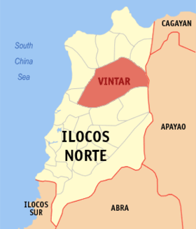
Vintar
Appearance
Page Module:Infobox/styles.css has no content.
| Vintar | |
|---|---|
| Baley na Filipinas | |
 | |
 Lokasyon na Vintar | |
 | |
| 18°13′50″N 120°38′56″E | |
| Dalin | Filipinas |
| Angipaletnegan | 1909 |
| Barangay | 33 |
| Kaawang | |
| • Katiponan | 614.35 km2 (237.20 sq mi) |
| Elebasyon | 59 m (194 ft) |
| Bilang na too (Mayo 1, 2020)[1] | |
| • Katiponan | 33,339 |
| • Densidad | 54/km2 (140/sq mi) |
| Economia | |
| • Clase | unaan ya klase ya baley |
| • Ingresos | ₱261,741,730.99 (2020) |
| • Activos | ₱526,949,182.81 (2020) |
| • Pasivos | ₱118,022,569.68 (2020) |
| • Gastos | ₱204,841,883.16 (2020) |
| Kodigo na postal | 2915 |
| Kodigo na lugar | 77 |
Say Vintar et unaan ya klase ya baley ed luyag na Ilocos ed Baybay, Filipinas. Unong ed 1 Mayo 2020 census, say populasyon to et 33,339 totoo tan 8,422 abong. Walay kabaleg tan sukat to ya 614.35 sq. km. Say zip code to et 2915.
Saray barangay
[dumaen | dumaen so pinanlapuan]- Abkir
- Alsem
- Bago
- Bulbulala
- Cabangaran
- Cabayo
- Cabisocolan
- Canaam
- Columbia
- Dagupan
- Diaton
- Dipilat
- Esperanza
- Ester
- Isic Isic
- Lubnac
- Mabanbanag
- Alejo Malasig
- Manarang
- Margaay
- Namoroc
- Malampa (Peninaan-Malampa)
- Parparoroc
- Parut
- Salsalamagui
- San Jose (Lipay)
- San Nicolas (Pob.)
- San Pedro (Pob.)
- San Ramon (Pob.)
- San Roque (Pob.)
- Santa Maria (Pob.)
- Tamdagan
- Visaya
Demograpiko
[dumaen | dumaen so pinanlapuan]| Taon | Pop. | ±% p.a. |
|---|---|---|
| 1903 | 9,435 | — |
| 1918 | 11,686 | +1.44% |
| 1939 | 14,153 | +0.92% |
| 1948 | 14,882 | +0.56% |
| 1960 | 17,359 | +1.29% |
| 1970 | 19,455 | +1.15% |
| 1975 | 21,655 | +2.17% |
| 1980 | 23,356 | +1.52% |
| 1990 | 27,084 | +1.49% |
| 1995 | 27,460 | +0.26% |
| 2000 | 29,031 | +1.20% |
| 2007 | 29,405 | +0.18% |
| 2010 | 31,448 | +2.47% |
| 2015 | 32,220 | +0.46% |
| 2020 | 33,339 | +0.67% |
| Reperensiya: Philippine Statistics Authority[2][3][4] | ||
Saray reperensiya
[dumaen | dumaen so pinanlapuan]- ↑ "2020 Census of Population and Housing (2020 CPH) Population Counts Declared Official by the President". Hulyo 7, 2021. https://psa.gov.ph/content/2020-census-population-and-housing-2020-cph-population-counts-declared-official-president.
- ↑ Census of Population (2015). "Region I (Ilocos Region)". Total Population by Province, City, Municipality and Barangay. PSA. Retrieved 29 June 2016.
- ↑ Census of Population and Housing (2010). "Region I (Ilocos Region)". Total Population by Province, City, Municipality and Barangay. NSO. Retrieved 29 June 2016.
- ↑ Censuses of Population (1903–2007). "Region I (Ilocos Region)". Table 1. Population Enumerated in Various Censuses by Province/Highly Urbanized City: 1903 to 2007. NSO.
