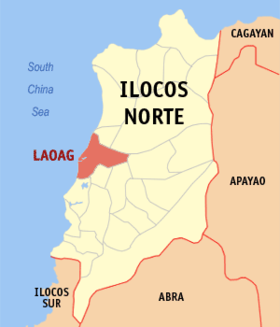
Laoag
Appearance
Page Module:Infobox/styles.css has no content.
| Laoag | |
|---|---|
| Siyudad | |
 | |
 Lokasyon na Laoag | |
 | |
| 18°11′52″N 120°35′37″E | |
| Dalin | Filipinas |
| Barangay | 80 |
| Kaawang | |
| • Katiponan | 116.08 km2 (44.82 sq mi) |
| Elebasyon | 57 m (187 ft) |
| Bilang na too (Mayo 1, 2020)[1] | |
| • Katiponan | 111,651 |
| • Densidad | 960/km2 (2,500/sq mi) |
| Economia | |
| • Clase | kumatlo ya klase a siyudad |
| • Ingresos | ₱873,509,698.39 (2020) |
| • Activos | ₱2,313,774,829.15 (2020) |
| • Pasivos | ₱684,655,231.92 (2020) |
| • Gastos | ₱716,453,120.88 (2020) |
| Kodigo na postal | 2900 |
| Kodigo na lugar | 77 |
| Website | www |
Say Laoag et kumatlo ya klase a siyudad ed luyag na Ilocos ed Baybay, Filipinas. Unong ed 1 Mayo 2020 census, say populasyon to et 111,651 totoo tan 27,875 abong. Walay kabaleg tan sukat to ya 116.08 sq. km. Say zip code to et 2900.
Saray barangay
[dumaen | dumaen so pinanlapuan]Say Siyudad na Laoag walay 80 ya barangay.
- Bgy. No. 42, Apaya
- Bgy. No. 36, Araniw
- Bgy. No. 56-A, Bacsil North
- Bgy. No. 56-B, Bacsil South
- Bgy. No. 41, Balacad
- Bgy. No. 40, Balatong
- Bgy. No. 55-A, Barit-Pandan
- Bgy. No. 47, Bengcag
- Bgy. No. 50, Buttong
- Bgy. No. 60-A, Caaoacan
- Bry. No. 48-A, Cabungaan North
- Bgy. No. 48-B, Cabungaan South
- Bgy. No. 37, Calayab
- Bgy. No. 54-A, Camangaan
- Bgy. No. 58, Casili
- Bgy. No. 61, Cataban
- Bgy. No. 43, Cavit
- Bgy. No. 49-A, Darayday
- Bgy. No. 59-B, Dibua North
- Bgy. No. 59-A, Dibua South
- Bgy. No. 34-B, Gabu Norte East
- Bgy. No. 34-A, Gabu Norte West
- Bgy. No. 35, Gabu Sur
- Bgy. No. 32-C La Paz East
- Bgy. No. 33-B, La Paz Proper
- Bgy. No. 32-B, La Paz West
- Bgy. No. 54-B, Lagui-Sail
- Bgy. No. 32-A, La Paz East
- Bgy. No. 33-A, La Paz Proper
- Bgy. No. 52-B, Lataag
- Bgy. No. 60-B, Madiladig
- Bgy. No. 38-A, Mangato East
- Bgy. No. 38-B, Mangato West
- Bgy. No. 62-A, Navotas North
- Bgy. No. 62-B, Navotas South
- Bgy. No. 46, Nalbo
- Bgy. No. 51-A, Nangalisan East
- Bgy. No. 51-B, Nangalisan West
- Bgy. No. 24, Nstra. Sra. De Consolacion(Pob.)
- Bgy. No. 7-A, Nstra. Sra. De Natividad (Pob.)
- Bgy. No. 7-B, Nstra. Sra. De Natividad (Pob.)
- Bgy. No. 27, Nstra. Sra. De Soledad (Pob.)
- Bgy. No. 13, Nstra. Sra. De Visitacion (Pob.)
- Bgy. No. 3, Nstra. Sra. Del Rosario (Pob.)
- Bgy. No. 57, Pila
- Bgy. No. 49-B, Raraburan
- Bgy. No. 53, Rioeng
- Bgy. No. 55-B, Salet-Bulango
- Bgy. No. 6, San Agustin (Pob.)
- Bgy. No. 22, San Andres (Pob.)
- Bgy. No. 28, San Bernardo (Pob.)
- Bgy. No. 17, San Francisco (Pob.)
- Bgy. No. 4, San Guillermo (Pob.)
- Bgy. No. 15, San Guillermo (Pob.)
- Bgy. No. 12, San Isidro (Pob.)
- Bgy. No. 16, San Jacinto (Pob.)
- Bgy. No. 10, San Jose (Pob.)
- Bgy. No. 1, San Lorenzo (Pob.)
- Bgy. No. 26, San Marcelino (Pob.)
- Bgy. No. 52-A, San Mateo
- Bgy. No. 23, San Matias (Pob.)
- Bgy. No. 20, San Miguel (Pob.)
- Bgy. No. 21, San Pedro (Pob.)
- Bgy. No. 5, San Pedro (Pob.)
- Bry. No. 18, San Quirino (Pob.)
- Bgy. No. 8, San Vicente (Pob.)
- Bgy. No. 9, Santa Angela (Pob.)
- Bgy. No. 11, Santa Balbina (Pob.)
- Bgy. No. 25, Santa Cayetana
- Bgy. No. 2, Santa Joaquina (Pob.)
- Bgy. No. 19, Santa Marcela (Pob.)
- Bgy. No. 30-B, Santa Maria
- Bgy. No. 39, Santa Rosa
- Bgy. No. 14, Santo Tomas (Pob.)
- Bgy. No. 29, Santo Tomas (Pob.)
- Bgy. No. 30-A, Suyo
- Bgy. No. 31, Talingaan
- Bgy. No. 45, Tangid
- Bgy. No. 55-C, Vira
- Bgy. No. 44, Zamboanga
Demograpiko
[dumaen | dumaen so pinanlapuan]| Taon | Pop. | ±% p.a. |
|---|---|---|
| 1903 | 34,454 | — |
| 1918 | 38,469 | +0.74% |
| 1939 | 41,842 | +0.40% |
| 1948 | 44,406 | +0.66% |
| 1960 | 50,198 | +1.03% |
| 1970 | 61,727 | +2.09% |
| 1975 | 66,259 | +1.43% |
| 1980 | 69,648 | +1.00% |
| 1990 | 83,756 | +1.86% |
| 1995 | 88,336 | +1.00% |
| 2000 | 94,466 | +1.45% |
| 2007 | 102,457 | +1.13% |
| 2010 | 104,904 | +0.86% |
| 2015 | 111,125 | +1.10% |
| 2020 | 111,651 | +0.09% |
| Reperensiya: Philippine Statistics Authority[2][3][4] | ||
Saray Medya
[dumaen | dumaen so pinanlapuan]Saray Radio
[dumaen | dumaen so pinanlapuan]Saray estasiyon diad AM
[dumaen | dumaen so pinanlapuan]- Audiovisual Communicators, Inc. (PA) 675
- People's Broadcasting Service DZVR 711
- Pacific Broadcasting System DZJC 747
- Swara Sug Media Corporation DWAR 819
Saray reperensiya
[dumaen | dumaen so pinanlapuan]- ↑ "2020 Census of Population and Housing (2020 CPH) Population Counts Declared Official by the President". Hulyo 7, 2021. https://psa.gov.ph/content/2020-census-population-and-housing-2020-cph-population-counts-declared-official-president.
- ↑ Census of Population (2015). "Region I (Ilocos Region)". Total Population by Province, City, Municipality and Barangay. PSA. Retrieved 29 June 2016.
- ↑ Census of Population and Housing (2010). "Region I (Ilocos Region)". Total Population by Province, City, Municipality and Barangay. NSO. Retrieved 29 June 2016.
- ↑ Censuses of Population (1903–2007). "Region I (Ilocos Region)". Table 1. Population Enumerated in Various Censuses by Province/Highly Urbanized City: 1903 to 2007. NSO.
