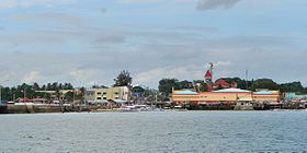
Talibon
Appearance
Page Module:Infobox/styles.css has no content.
| Talibon | ||
|---|---|---|
| Baley na Filipinas | ||
 | ||
| ||
 Lokasyon na Talibon | ||
 | ||
| 10°7′12″N 124°16′48″E | ||
| Dalin | Filipinas | |
| Angipaletnegan | 1830 | |
| Barangay | 25 | |
| Kaawang | ||
| • Katiponan | 140.46 km2 (54.23 sq mi) | |
| Elebasyon | 7 m (23 ft) | |
| Bilang na too (Mayo 1, 2020)[1] | ||
| • Katiponan | 71,272 | |
| • Densidad | 510/km2 (1,300/sq mi) | |
| Economia | ||
| • Clase | unaan ya klase ya baley | |
| • Ingresos | ₱257,974,270.72 (2020) | |
| • Activos | ₱613,791,107.63 (2020) | |
| • Pasivos | ₱96,582,412.10 (2020) | |
| • Gastos | ₱282,960,746.73 (2020) | |
| Kodigo na postal | 6325 | |
| Kodigo na lugar | 38 | |
| Website | www | |
Say Talibon et unaan ya klase ya baley ed luyag na Bohol, Filipinas. Unong ed 1 Mayo 2020 census, say populasyon to et 71,272 totoo tan 16,515 abong. Walay kabaleg tan sukat to ya 140.46 sq. km. Say zip code to et 6325.
Saray barangay
[dumaen | dumaen so pinanlapuan]- Bagacay
- Balintawak
- Burgos
- Busalian
- Calituban
- Cataban
- Guindacpan
- Magsaysay
- Mahanay
- Nocnocan
- Poblacion
- Rizal
- Sag
- San Agustin
- San Carlos
- San Francisco
- San Isidro
- San Jose
- San Pedro
- San Roque
- Santo Niño
- Sikatuna
- Suba
- Tanghaligue
- Zamora
Demograpiko
[dumaen | dumaen so pinanlapuan]| Taon | Pop. | ±% p.a. |
|---|---|---|
| 1903 | 6,085 | — |
| 1918 | 12,227 | +4.76% |
| 1939 | 26,077 | +3.67% |
| 1948 | 23,455 | −1.17% |
| 1960 | 30,640 | +2.25% |
| 1970 | 35,223 | +1.40% |
| 1975 | 41,270 | +3.23% |
| 1980 | 46,110 | +2.24% |
| 1990 | 41,873 | −0.96% |
| 1995 | 44,854 | +1.30% |
| 2000 | 54,147 | +4.12% |
| 2007 | 59,274 | +1.26% |
| 2010 | 61,373 | +1.27% |
| 2015 | 66,969 | +1.68% |
| 2020 | 71,272 | +1.23% |
| Reperensiya: Philippine Statistics Authority[2][3][4] | ||
Saray reperensiya
[dumaen | dumaen so pinanlapuan]- ↑ "2020 Census of Population and Housing (2020 CPH) Population Counts Declared Official by the President". Hulyo 7, 2021. https://psa.gov.ph/content/2020-census-population-and-housing-2020-cph-population-counts-declared-official-president.
- ↑ Census of Population (2015). "Region VII (Central Visayas)". Total Population by Province, City, Municipality and Barangay. PSA. Retrieved 29 June 2016.
- ↑ Census of Population and Housing (2010). "Region VII (Central Visayas)". Total Population by Province, City, Municipality and Barangay. NSO. Retrieved 29 June 2016.
- ↑ Censuses of Population (1903–2007). "Region VII (Central Visayas)". Table 1. Population Enumerated in Various Censuses by Province/Highly Urbanized City: 1903 to 2007. NSO.
Saray gawing ed labas
[dumaen | dumaen so pinanlapuan]- PhilAtlas.com
- Philippine Standard Geographic Code
- Local Governance Performance Management System
- www
.talibon-bohol .gov .ph

