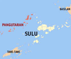
Pangutaran
Appearance
Page Module:Infobox/styles.css has no content.
| Pangutaran | |
|---|---|
| Baley na Filipinas | |
 Lokasyon na Pangutaran | |
 | |
| 6°18′0″N 120°34′48″E | |
| Dalin | Filipinas |
| Barangay | 16 |
| Kaawang | |
| • Katiponan | 258.10 km2 (99.65 sq mi) |
| Elebasyon | 1 m (3 ft) |
| Bilang na too (Mayo 1, 2020)[1] | |
| • Katiponan | 36,374 |
| • Densidad | 140/km2 (370/sq mi) |
| Economia | |
| • Clase | kumapat ya klase ya baley |
| • Ingresos | ₱153,690,234.18 (2020) |
| • Activos | ₱224,989,182.34 (2020) |
| • Pasivos | ₱83,483,424.77 (2020) |
| • Gastos | ₱130,214,443.41 (2020) |
| Kodigo na postal | 7414 |
| Kodigo na lugar | 68 |
Say Pangutaran et kumapat ya klase ya baley ed luyag na Sulu, Filipinas. Unong ed 1 Mayo 2020 census, say populasyon to et 36,374 totoo tan 6,592 abong. Walay kabaleg tan sukat to ya 258.10 sq. km. Say zip code to et 7414.
Saray barangay
[dumaen | dumaen so pinanlapuan]- Alu Bunah
- Bangkilay
- Kawitan
- Kehi Niog
- Lantong Babag
- Lumah Dapdap
- Pandan Niog
- Panducan
- Panitikan
- Patutol
- Se-ipang
- Simbahan (Pob.)
- Suang Bunah
- Tonggasang
- Tubig Nonok
- Tubig Sallang
Demograpiko
[dumaen | dumaen so pinanlapuan]| Taon | Pop. | ±% p.a. |
|---|---|---|
| 1903 | 1,201 | — |
| 1918 | 2,982 | +6.25% |
| 1939 | 7,442 | +4.45% |
| 1948 | 8,536 | +1.54% |
| 1960 | 10,235 | +1.52% |
| 1970 | 16,172 | +4.68% |
| 1975 | 17,823 | +1.97% |
| 1980 | 19,311 | +1.62% |
| 1990 | 17,122 | −1.20% |
| 1995 | 22,846 | +5.55% |
| 2000 | 26,211 | +2.99% |
| 2007 | 29,571 | +1.68% |
| 2010 | 28,461 | −1.38% |
| 2015 | 30,613 | +1.40% |
| 2020 | 36,374 | +3.45% |
| Reperensiya: Philippine Statistics Authority[2][3][4] | ||
Saray reperensiya
[dumaen | dumaen so pinanlapuan]- ↑ "2020 Census of Population and Housing (2020 CPH) Population Counts Declared Official by the President". Hulyo 7, 2021. https://psa.gov.ph/content/2020-census-population-and-housing-2020-cph-population-counts-declared-official-president.
- ↑ Census of Population (2015). "ARMM – Autonomous Region in Muslim Mindanao". Total Population by Province, City, Municipality and Barangay. PSA. Retrieved 29 June 2016.
- ↑ Census of Population and Housing (2010). "ARMM – Autonomous Region in Muslim Mindanao". Total Population by Province, City, Municipality and Barangay. NSO. Retrieved 29 June 2016.
- ↑ Censuses of Population (1903–2007). "ARMM – Autonomous Region in Muslim Mindanao". Table 1. Population Enumerated in Various Censuses by Province/Highly Urbanized City: 1903 to 2007. NSO.
