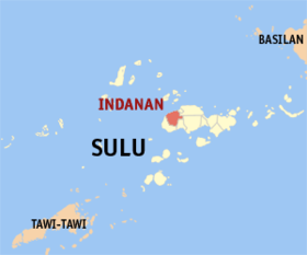
Indanan
Appearance
Page Module:Infobox/styles.css has no content.
| Indanan | |
|---|---|
| Baley na Filipinas | |
 Lokasyon na Indanan | |
 | |
| 6°0′0″N 120°58′12″E | |
| Dalin | Filipinas |
| Barangay | 34 |
| Kaawang | |
| • Katiponan | 170.72 km2 (65.92 sq mi) |
| Elebasyon | 202 m (663 ft) |
| Bilang na too (Mayo 1, 2020)[1] | |
| • Katiponan | 93,168 |
| • Densidad | 550/km2 (1,400/sq mi) |
| Economia | |
| • Clase | kumatlo ya klase ya baley |
| • Ingresos | ₱222,911,110.8394,468,722.1586,546,785.2298,392,268.97112,227,282.44123,756,935.73153,571,734.39164,188,398.74183,089,924.09220,934,425.50319,573,526.77 (2020) |
| • Activos | ₱231,689,254.2235,079,730.8446,932,569.9184,647,731.2194,158,007.9989,679,560.81102,862,943.56143,428,696.86165,103,275.48338,628,350.84446,975,352.65 (2020) |
| • Pasivos | ₱81,630,145.137,731,011.4717,463,343.6043,241,553.6342,081,635.4128,598,283.6141,573,616.7761,841,942.5767,449,303.25100,106,154.80115,922,420.76 (2020) |
| • Gastos | ₱158,852,420.4011,069,157.7277,587,960.0180,195,617.8097,473,347.76105,288,031.11116,248,193.76119,549,494.24174,276,207.38224,621,330.92 (2020) |
| Kodigo na postal | 7407 |
| Kodigo na lugar | 68 |
| Website | www |
Say Indanan et kumatlo ya klase ya baley ed luyag na Sulu, Filipinas. Unong ed 1 Mayo 2020 census, say populasyon to et 93,168 totoo tan 15,839 abong. Walay kabaleg tan sukat to ya 170.72 sq. km. Say zip code to et 7407.
Saray barangay
[dumaen | dumaen so pinanlapuan]- Adjid
- Bangalan
- Bato-bato
- Buanza
- Bud-Taran
- Bunut
- Jati-Tunggal
- Kabbon Maas
- Kagay
- Kajatian
- Kan Islam
- Kandang Tukay
- Karawan
- Katian
- Kuppong
- Lambayong
- Langpas
- Licup
- Malimbaya
- Manggis
- Manilop
- Paligue
- Panabuan
- Panglima Misuari (Sasak)
- Pasil
- Poblacion (Indanan)
- Sapah Malaum
- Sawaki
- Sionogan
- Tagbak
- Timbangan
- Tubig Dakulah
- Tubig Parang
- Tumantangis
Demograpiko
[dumaen | dumaen so pinanlapuan]| Taon | Pop. | ±% p.a. |
|---|---|---|
| 1918 | 7,076 | — |
| 1939 | 18,959 | +4.81% |
| 1948 | 17,722 | −0.75% |
| 1960 | 23,381 | +2.34% |
| 1970 | 26,380 | +1.21% |
| 1975 | 6,234 | −25.12% |
| 1980 | 32,074 | +38.75% |
| 1990 | 41,969 | +2.73% |
| 1995 | 46,140 | +1.79% |
| 2000 | 53,425 | +3.19% |
| 2007 | 85,220 | +6.65% |
| 2010 | 65,858 | −8.95% |
| 2015 | 80,883 | +3.99% |
| 2020 | 93,168 | +2.82% |
| Reperensiya: Philippine Statistics Authority[2][3][4] | ||
Saray reperensiya
[dumaen | dumaen so pinanlapuan]- ↑ "2020 Census of Population and Housing (2020 CPH) Population Counts Declared Official by the President". Hulyo 7, 2021. https://psa.gov.ph/content/2020-census-population-and-housing-2020-cph-population-counts-declared-official-president.
- ↑ Census of Population (2015). "ARMM – Autonomous Region in Muslim Mindanao". Total Population by Province, City, Municipality and Barangay. PSA. Retrieved 29 June 2016.
- ↑ Census of Population and Housing (2010). "ARMM – Autonomous Region in Muslim Mindanao". Total Population by Province, City, Municipality and Barangay. NSO. Retrieved 29 June 2016.
- ↑ Censuses of Population (1903–2007). "ARMM – Autonomous Region in Muslim Mindanao". Table 1. Population Enumerated in Various Censuses by Province/Highly Urbanized City: 1903 to 2007. NSO.
