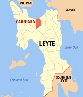
Carigara
Appearance
| Carigara | |
|---|---|
| Baley na Filipinas | |
 | |
 Lokasyon na Carigara | |
 | |
| 11°18′0″N 124°40′48″E | |
| Dalin | Filipinas |
| Barangay | 49 |
| Kaawang | |
| • Katiponan | 117.86 km2 (45.51 sq mi) |
| Elebasyon | 130 m (430 ft) |
| Bilang na too (Mayo 1, 2020)[1] | |
| • Katiponan | 54,656 |
| • Densidad | 460/km2 (1,200/sq mi) |
| Economia | |
| • Clase | kumadua ya klase ya baley |
| • Ingresos | ₱192,246,637.02 (2020) |
| • Activos | ₱606,129,666.64 (2020) |
| • Pasivos | ₱160,834,424.88 (2020) |
| • Gastos | ₱156,610,346.67 (2020) |
| Kodigo na postal | 6529 |
| Kodigo na lugar | 53 |
| Website |
www |
Say Carigara et kumadua ya klase ya baley ed luyag na Leyte, Filipinas. Unong ed 1 Mayo 2020 census, say populasyon to et 54,656 totoo tan 12,830 abong. Walay kabaleg tan sukat to ya 117.86 sq. km. Say zip code to et 6529.
Saray barangay
[dumaen | dumaen so pinanlapuan]- Balilit
- Barayong
- Barugohay Central
- Barugohay Norte
- Barugohay Sur
- Baybay (Pob.)
- Binibihan
- Bislig
- Caghalo
- Camansi
- Canal
- Candigahub
- Canlampay
- Cogon
- Cutay
- East Visoria
- Guindapunan East
- Guindapunan West
- Hiluctogan
- Jugaban (Pob.)
- Libo
- Lower Hiraan
- Lower Sogod
- Macalpi
- Manloy
- Nauguisan
- Pangna
- Parag-um
- Parina
- Piloro
- Ponong (Pob.)
- Sagkahan
- San Mateo (Pob.)
- Santa Fe
- Sawang (Pob.)
- Tagak
- Tangnan
- Tigbao
- Tinaguban
- Upper Hiraan
- Upper Sogod
- Uyawan
- West Visoria
- Paglaum
- San Juan
- Bagong Lipunan
- Canfabi
- Rizal (Tagak East)
- San Isidro
Demograpiko
[dumaen | dumaen so pinanlapuan]| Taon | Pop. | ±% p.a. |
|---|---|---|
| 1903 | 16,382 | — |
| 1918 | 17,558 | +0.46% |
| 1939 | 23,236 | +1.34% |
| 1948 | 26,803 | +1.60% |
| 1960 | 26,761 | −0.01% |
| 1970 | 32,869 | +2.07% |
| 1975 | 34,194 | +0.80% |
| 1980 | 34,377 | +0.11% |
| 1990 | 38,863 | +1.23% |
| 1995 | 42,302 | +1.60% |
| 2000 | 43,455 | +0.58% |
| 2007 | 45,696 | +0.70% |
| 2010 | 47,444 | +1.38% |
| 2015 | 51,345 | +1.52% |
| 2020 | 54,656 | +1.24% |
| Reperensiya: Philippine Statistics Authority[2][3][4] | ||
Saray reperensiya
[dumaen | dumaen so pinanlapuan]- ↑ "2020 Census of Population and Housing (2020 CPH) Population Counts Declared Official by the President". Hulyo 7, 2021. https://psa.gov.ph/content/2020-census-population-and-housing-2020-cph-population-counts-declared-official-president.
- ↑ Census of Population (2015). "Region VIII (Eastern Visayas)". Total Population by Province, City, Municipality and Barangay. PSA. Retrieved 29 June 2016.
- ↑ Census of Population and Housing (2010). "Region VIII (Eastern Visayas)". Total Population by Province, City, Municipality and Barangay. NSO. Retrieved 29 June 2016.
- ↑ Censuses of Population (1903–2007). "Region VIII (Eastern Visayas)". Table 1. Population Enumerated in Various Censuses by Province/Highly Urbanized City: 1903 to 2007. NSO.
