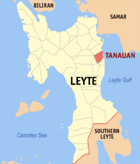
Tanauan, Leyte
Appearance
| Tanauan | |
|---|---|
| Baley na Filipinas | |
 | |
 Lokasyon na Tanauan | |
 | |
| 11°7′12″N 125°1′12″E | |
| Dalin | Filipinas |
| Barangay | 54 |
| Kaawang | |
| • Katiponan | 78.41 km2 (30.27 sq mi) |
| Elebasyon | 9 m (30 ft) |
| Bilang na too (Mayo 1, 2020)[1] | |
| • Katiponan | 57,455 |
| • Densidad | 730/km2 (1,900/sq mi) |
| Economia | |
| • Clase | kumadua ya klase ya baley |
| • Ingresos | ₱181,700,710.79 (2020) |
| • Activos | ₱598,334,065.63 (2020) |
| • Pasivos | ₱115,694,474.45 (2020) |
| • Gastos | ₱169,960,678.04 (2020) |
| Kodigo na postal | 6502 |
| Kodigo na lugar | 53 |
| Website |
www |
Say Tanauan et kumadua ya klase ya baley ed luyag na Leyte, Filipinas. Unong ed 1 Mayo 2020 census, say populasyon to et 57,455 totoo tan 14,892 abong. Walay kabaleg tan sukat to ya 78.41 sq. km. Say zip code to et 6502.
Saray barangay
[dumaen | dumaen so pinanlapuan]- Ada
- Amanluran
- Arado
- Atipolo
- Balud
- Bangon
- Bantagan
- Baras
- Binolo
- Binongto-an
- Bislig
- Cabalagnan
- Cabarasan Guti
- Cabonga-an
- Cabuynan
- Cahumayhumayan
- Calogcog
- Calsadahay
- Camire
- Canbalisara
- Catigbian
- Catmon
- Cogon
- Guindag-an
- Guingauan
- Hilagpad
- Lapay
- Limbuhan Daku
- Limbuhan Guti
- Linao
- Magay
- Maghulod
- Malaguicay
- Maribi
- Mohon
- Pago
- Pasil
- Picas
- Buntay (Poblacion)
- Canramos (Poblacion)
- Licod (Poblacion)
- San Miguel (Poblacion)
- Salvador
- San Isidro
- San Roque (Poblacion)
- San Victor
- Santa Cruz
- Santa Elena
- Santo Niño [Haclagan] (Poblacion)
- Solano
- Talolora
- Tugop
- Kiling
- Sacme
Demograpiko
[dumaen | dumaen so pinanlapuan]| Taon | Pop. | ±% p.a. |
|---|---|---|
| 1903 | 18,256 | — |
| 1918 | 18,880 | +0.22% |
| 1939 | 21,934 | +0.72% |
| 1948 | 24,573 | +1.27% |
| 1960 | 23,421 | −0.40% |
| 1970 | 29,438 | +2.31% |
| 1975 | 30,541 | +0.74% |
| 1980 | 31,487 | +0.61% |
| 1990 | 38,033 | +1.91% |
| 1995 | 40,716 | +1.29% |
| 2000 | 45,056 | +2.20% |
| 2007 | 47,426 | +0.71% |
| 2010 | 50,119 | +2.03% |
| 2015 | 55,021 | +1.79% |
| 2020 | 57,455 | +0.85% |
| Reperensiya: Philippine Statistics Authority[2][3][4] | ||
Saray reperensiya
[dumaen | dumaen so pinanlapuan]- ↑ "2020 Census of Population and Housing (2020 CPH) Population Counts Declared Official by the President". Hulyo 7, 2021. https://psa.gov.ph/content/2020-census-population-and-housing-2020-cph-population-counts-declared-official-president.
- ↑ Census of Population (2015). "Region VIII (Eastern Visayas)". Total Population by Province, City, Municipality and Barangay. PSA. Retrieved 29 June 2016.
- ↑ Census of Population and Housing (2010). "Region VIII (Eastern Visayas)". Total Population by Province, City, Municipality and Barangay. NSO. Retrieved 29 June 2016.
- ↑ Censuses of Population (1903–2007). "Region VIII (Eastern Visayas)". Table 1. Population Enumerated in Various Censuses by Province/Highly Urbanized City: 1903 to 2007. NSO.
