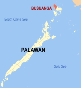
Busuanga
Appearance
Page Module:Infobox/styles.css has no content.
| Busuanga | |
|---|---|
| Baley na Filipinas | |
 | |
 Lokasyon na Busuanga | |
 | |
| 12°8′1″N 119°56′11″E | |
| Dalin | Filipinas |
| Barangay | 14 |
| Kaawang | |
| • Katiponan | 392.90 km2 (151.70 sq mi) |
| Elebasyon | 15 m (49 ft) |
| Bilang na too (Mayo 1, 2020)[1] | |
| • Katiponan | 25,617 |
| • Densidad | 65/km2 (170/sq mi) |
| Economia | |
| • Clase | kumatlo ya klase ya baley |
| • Ingresos | ₱174,400,145.9966,858,245.6577,495,943.0388,616,148.2299,839,768.18113,607,920.02123,099,826.23133,899,049.87146,726,222.01175,828,624.41240,349,132.08 (2020) |
| • Activos | ₱431,762,212.68104,495,439.98155,136,253.62195,789,446.60249,835,034.58317,441,323.51379,345,007.61427,261,105.74427,051,033.22428,955,772.19479,972,003.69 (2020) |
| • Pasivos | ₱147,973,042.5615,636,674.3418,144,710.3535,990,914.2995,707,460.70134,873,270.07108,444,431.31126,408,165.8292,142,512.13112,222,232.12105,288,214.52 (2020) |
| • Gastos | ₱178,143,988.6355,364,147.7051,748,286.6557,449,450.8371,410,291.3385,182,723.7989,769,517.26104,313,945.2599,223,417.75169,148,951.24189,050,211.71 (2020) |
| Kodigo na postal | 5317 |
| Kodigo na lugar | 48 |
Say Busuanga et kumatlo ya klase ya baley ed luyag na Palawan, Filipinas. Unong ed 1 Mayo 2020 census, say populasyon to et 25,617 totoo tan 6,397 abong. Walay kabaleg tan sukat to ya 392.90 sq. km. Say zip code to et 5317.
Saray barangay
[dumaen | dumaen so pinanlapuan]- Bogtong
- Buluang
- Cheey
- Concepcion
- Maglalambay
- New Busuanga (Pob.)
- Old Busuanga
- Panlaitan
- Quezon
- Sagrada
- Salvacion
- San Isidro
- San Rafael
- Santo Niño
Demograpiko
[dumaen | dumaen so pinanlapuan]| Taon | Pop. | ±% p.a. |
|---|---|---|
| 1960 | 4,424 | — |
| 1970 | 5,905 | +2.93% |
| 1975 | 6,934 | +3.27% |
| 1980 | 10,348 | +8.33% |
| 1990 | 11,007 | +0.62% |
| 1995 | 15,843 | +7.06% |
| 2000 | 16,287 | +0.59% |
| 2007 | 19,066 | +2.20% |
| 2010 | 21,358 | +4.22% |
| 2015 | 22,046 | +0.61% |
| 2020 | 25,617 | +3.00% |
| Reperensiya: Philippine Statistics Authority[2][3][4] | ||
Saray reperensiya
[dumaen | dumaen so pinanlapuan]- ↑ "2020 Census of Population and Housing (2020 CPH) Population Counts Declared Official by the President". Hulyo 7, 2021. https://psa.gov.ph/content/2020-census-population-and-housing-2020-cph-population-counts-declared-official-president.
- ↑ Census of Population (2015). "Region IV-B (Mimaropa)". Total Population by Province, City, Municipality and Barangay. PSA. Retrieved 29 June 2016.
- ↑ Census of Population and Housing (2010). "Region IV-B (Mimaropa)". Total Population by Province, City, Municipality and Barangay. NSO. Retrieved 29 June 2016.
- ↑ Censuses of Population (1903–2007). "Region IV-B (Mimaropa)". Table 1. Population Enumerated in Various Censuses by Province/Highly Urbanized City: 1903 to 2007. NSO.
Saray gawing ed labas
[dumaen | dumaen so pinanlapuan]
