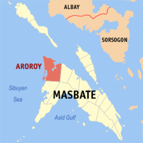
Aroroy
Appearance
Page Module:Infobox/styles.css has no content.
| Aroroy | |
|---|---|
| Baley na Filipinas | |
 Lokasyon na Aroroy | |
 | |
| 12°30′45″N 123°23′56″E | |
| Dalin | Filipinas |
| Angipaletnegan | 1904 |
| Barangay | 41 |
| Kaawang | |
| • Katiponan | 440.30 km2 (170.00 sq mi) |
| Elebasyon | 32 m (105 ft) |
| Bilang na too (Mayo 1, 2020)[1] | |
| • Katiponan | 88,351 |
| • Densidad | 200/km2 (520/sq mi) |
| Economia | |
| • Clase | unaan ya klase ya baley |
| • Ingresos | ₱573,474,826.71210,534,105.86234,367,785.07275,431,894.35326,847,936.44351,042,414.83207,779,852.29228,878,392.14507,814,771.13494,925,589.45941,630,505.23 (2020) |
| • Activos | ₱1,191,742,118.26445,691,990.68404,419,937.68568,047,503.56797,213,399.00901,942,808.27540,402,319.81582,060,351.591,083,837,546.951,776,112,108.692,511,197,295.53 (2020) |
| • Pasivos | ₱217,464,716.61106,742,304.8091,956,902.07198,247,425.89344,973,735.05344,978,208.41124,690,718.0893,904,547.44285,742,452.75301,332,025.70578,811,184.95 (2020) |
| • Gastos | ₱394,071,373.18120,535,629.86127,479,734.01154,255,366.19201,798,319.68246,446,177.03156,481,240.17186,011,116.07375,595,261.40419,039,143.02499,746,336.45 (2020) |
| Kodigo na postal | 5414 |
| Kodigo na lugar | 56 |
| Website | www |
Say Aroroy et unaan ya klase ya baley ed luyag na Masbate, Filipinas. Unong ed 1 Mayo 2020 census, say populasyon to et 88,351 totoo tan 18,792 abong. Walay kabaleg tan sukat to ya 440.30 sq. km. Say zip code to et 5414.
Saray barangay
[dumaen | dumaen so pinanlapuan]Say Aroroy walay 41 ya barangay.
- Ambolong
- Amoroy
- Amutag
- Bagauma
- Balawing
- Balete
- Bangon
- Cabangcalan
- Cabas-An
- Calanay
- Capsay
- Concepcion
- Dayhagan
- Don Pablo Dela Rosa
- Gumahang
- Jaboyoan
- Lanang
- Luy-a
- Macabug
- Malubi
- Managanaga
- Manamoc
- Mariposa
- Mataba
- Matalangtalang
- Matangog
- Nabongsoran
- Pangle
- Panique
- Pinanaan
- Poblacion
- Puro
- San Agustin
- San Isidro
- Sawang
- Syndicate
- Talabaan
- Talib
- Tigbao
- Tinago
- Tinigban
Demograpiko
[dumaen | dumaen so pinanlapuan]| Taon | Pop. | ±% p.a. |
|---|---|---|
| 1918 | 9,836 | — |
| 1939 | 31,289 | +5.67% |
| 1948 | 23,888 | −2.95% |
| 1960 | 18,371 | −2.16% |
| 1970 | 28,624 | +4.53% |
| 1975 | 30,457 | +1.25% |
| 1980 | 38,618 | +4.86% |
| 1990 | 53,060 | +3.23% |
| 1995 | 55,110 | +0.71% |
| 2000 | 58,751 | +1.38% |
| 2007 | 62,635 | +0.89% |
| 2010 | 76,139 | +7.36% |
| 2015 | 86,168 | +2.38% |
| 2020 | 88,351 | +0.49% |
| Reperensiya: Philippine Statistics Authority[2][3][4] | ||
Saray reperensiya
[dumaen | dumaen so pinanlapuan]- ↑ "2020 Census of Population and Housing (2020 CPH) Population Counts Declared Official by the President". Hulyo 7, 2021. https://psa.gov.ph/content/2020-census-population-and-housing-2020-cph-population-counts-declared-official-president.
- ↑ Census of Population (2015). "Region V (Bicol Region)". Total Population by Province, City, Municipality and Barangay. PSA. Retrieved 29 June 2016.
- ↑ Census of Population and Housing (2010). "Region V (Bicol Region)". Total Population by Province, City, Municipality and Barangay. NSO. Retrieved 29 June 2016.
- ↑ Censuses of Population (1903–2007). "Region V (Bicol Region)". Table 1. Population Enumerated in Various Censuses by Province/Highly Urbanized City: 1903 to 2007. NSO.
