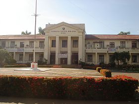
Siyudad na Masbate
Appearance
| Siyudad na Masbate | ||
|---|---|---|
| Siyudad | ||
 | ||
| ||
 Lokasyon na Siyudad na Masbate | ||
 | ||
| 12°22′26″N 123°37′29″E | ||
| Dalin | Filipinas | |
| Barangay | 20 | |
| Kaawang | ||
| • Katiponan | 188.00 km2 (72.59 sq mi) | |
| Elebasyon | 68 m (223 ft) | |
| Bilang na too (Mayo 1, 2020)[1] | ||
| • Katiponan | 104,522 | |
| • Densidad | 560/km2 (1,400/sq mi) | |
| Economia | ||
| • Clase | kumapat ya klase a siyudad | |
| • Ingresos | ₱707,732,385.34 (2020) | |
| • Activos | ₱1,607,673,077.43 (2020) | |
| • Pasivos | ₱453,255,011.01 (2020) | |
| • Gastos | ₱601,001,410.40 (2020) | |
| Kodigo na postal | 5400 | |
| Kodigo na lugar | 56 | |
| Website |
www | |
Say Siyudad na Masbate et kumapat ya klase a siyudad ed luyag na Masbate, Filipinas. Unong ed 1 Mayo 2020 census, say populasyon to et 104,522 totoo tan 22,357 abong. Walay kabaleg tan sukat to ya 188.00 sq. km. Say zip code to et 5400.
Saray barangay
[dumaen | dumaen so pinanlapuan]Say Siyudad na Masbate walay 34 ya barangay.
- Anas
- Asid
- B. Titong
- Bagalihog
- Bagumbayan
- Bantigue
- Bapor (Pob.)
- Batuhan
- Bayombon
- Biyong
- Bolo
- Cagay
- Cagba
- Cawayan Exterior
- Cawayan Interior
- Centro (Pob.)
- Espinosa
- F. Magallanes
- Ibingay
- Igang
- Kalipay (Pob.)
- Kinamaligan
- Malinta
- Mapiña
- Mayngaran
- Nursery
- Pating (Pob.)
- Pawa
- Sinalongan
- Talahib
- Tiongson
- Tugbo
- Ubongan Dacu
- Usab
Demograpiko
[dumaen | dumaen so pinanlapuan]| Taon | Pop. | ±% p.a. |
|---|---|---|
| 1903 | 5,235 | — |
| 1918 | 10,821 | +4.96% |
| 1939 | 23,312 | +3.72% |
| 1948 | 24,999 | +0.78% |
| 1960 | 31,613 | +1.98% |
| 1970 | 45,591 | +3.72% |
| 1975 | 46,728 | +0.50% |
| 1980 | 52,944 | +2.53% |
| 1990 | 58,714 | +1.04% |
| 1995 | 66,049 | +2.23% |
| 2000 | 71,441 | +1.70% |
| 2007 | 81,585 | +1.85% |
| 2010 | 85,227 | +1.60% |
| 2015 | 95,389 | +2.17% |
| 2020 | 104,522 | +1.81% |
| Reperensiya: Philippine Statistics Authority[2][3][4] | ||
Saray reperensiya
[dumaen | dumaen so pinanlapuan]- ↑ "2020 Census of Population and Housing (2020 CPH) Population Counts Declared Official by the President". Hulyo 7, 2021. https://psa.gov.ph/content/2020-census-population-and-housing-2020-cph-population-counts-declared-official-president.
- ↑ Census of Population (2015). "Region V (Bicol Region)". Total Population by Province, City, Municipality and Barangay. PSA. Retrieved 29 June 2016.
- ↑ Census of Population and Housing (2010). "Region V (Bicol Region)". Total Population by Province, City, Municipality and Barangay. NSO. Retrieved 29 June 2016.
- ↑ Censuses of Population (1903–2007). "Region V (Bicol Region)". Table 1. Population Enumerated in Various Censuses by Province/Highly Urbanized City: 1903 to 2007. NSO.

