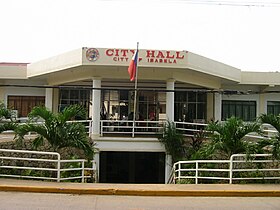
Siyudad na Isabela
Appearance
Page Module:Infobox/styles.css has no content.
| Isabella | |
|---|---|
| Siyudad | |
 | |
 Lokasyon na Isabella | |
 | |
| 6°42′0″N 121°58′12″E | |
| Dalin | Filipinas |
| Angipaletnegan | 1848 |
| Barangay | 45 |
| Kaawang[1] | |
| • Katiponan | 223.73 km2 (86.38 sq mi) |
| Elebasyon | 96 m (315 ft) |
| Bilang na too (Mayo 1, 2020)[2] | |
| • Katiponan | 130,379 |
| • Densidad | 580/km2 (1,500/sq mi) |
| Economia | |
| • Clase | kumapat ya klase a siyudad |
| • Ingresos | ₱707,902,236.39 (2020) |
| • Activos | ₱1,599,108,721.98 (2020) |
| • Pasivos | ₱364,382,005.06 (2020) |
| • Gastos | ₱513,119,026.18 (2020) |
| Kodigo na postal | 7300 |
| Kodigo na lugar | 62 |
| Website | www |
Say Siyudad na Isabela et kumapat ya klase a siyudad ed luyag na Zamboanga Peninsula, Filipinas. Unong ed 1 Mayo 2020 census, say populasyon to et 130,379 totoo tan 26,649 abong. Walay kabaleg tan sukat to ya 223.73 sq. km. Say zip code to et 7300.
Saray barangay
[dumaen | dumaen so pinanlapuan]- Aguada
- Balatanay
- Baluno (Latuan)
- Begang
- Binuangan
- Busay
- Cabunbata
- Calvario
- Carbon
- Diki
- Isabela Eastside (Pob.)
- Isabela Proper (Pob.)
- Dona Ramona T. Alano
- Kapatagan Grande
- Kaumpurnah Zone I
- Kaumpurnah Zone II
- Kaumpurnah Zone III
- Kumalarang
- La Piedad (Pob.)
- Lampinigan
- Lanote
- Lukbuton
- Lumbang
- Makiri
- Maligue (Lunot)
- Marang-marang
- Marketsite (Pob.)
- Menzi
- Panigayan
- Panunsulan
- Port Area (Pob.)
- Riverside
- San Rafael
- Santa Barbara
- Santa Cruz (Pob.)
- Seaside (Pob.)
- Sumagdang
- Sunrise Village (Pob.)
- Tabiawan
- Tabuk (Pob.)
- Timpul
- Kapayawan
- Masola
- Small Kapatagan
- Tampalan
Demograpiko
[dumaen | dumaen so pinanlapuan]| Taon | Pop. | ±% p.a. |
|---|---|---|
| 1903 | 4,480 | — |
| 1918 | 23,089 | +11.55% |
| 1939 | 57,561 | +4.45% |
| 1948 | 110,297 | +7.49% |
| 1960 | 32,609 | −9.65% |
| 1970 | 34,878 | +0.67% |
| 1975 | 48,092 | +6.65% |
| 1980 | 49,891 | +0.74% |
| 1990 | 59,078 | +1.70% |
| 1995 | 68,557 | +2.83% |
| 2000 | 73,032 | +1.36% |
| 2007 | 87,985 | +2.60% |
| 2010 | 97,857 | +3.95% |
| 2015 | 112,788 | +2.74% |
| 2020 | 130,379 | +2.89% |
| Reperensiya: Philippine Statistics Authority[3][4][5] | ||
Saray reperensiya
[dumaen | dumaen so pinanlapuan]- ↑ Error: Unable to display the reference properly. See the documentation for details.
- ↑ "2020 Census of Population and Housing (2020 CPH) Population Counts Declared Official by the President". Hulyo 7, 2021. https://psa.gov.ph/content/2020-census-population-and-housing-2020-cph-population-counts-declared-official-president.
- ↑ Census of Population (2015). "Region IX (Zamboanga Peninsula)". Total Population by Province, City, Municipality and Barangay. PSA. Retrieved 29 June 2016.
- ↑ Census of Population and Housing (2010). "Region IX (Zamboanga Peninsula)". Total Population by Province, City, Municipality and Barangay. NSO. Retrieved 29 June 2016.
- ↑ Censuses of Population (1903–2007). "Region IX (Zamboanga Peninsula)". Table 1. Population Enumerated in Various Censuses by Province/Highly Urbanized City: 1903 to 2007. NSO.
