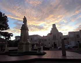
Sariaya
Appearance
| Sariaya | ||
|---|---|---|
| Baley na Filipinas | ||
 | ||
| ||
 Lokasyon na Sariaya | ||
 | ||
| 13°58′12″N 121°31′48″E | ||
| Dalin | Filipinas | |
| Barangay | 43 | |
| Kaawang | ||
| • Katiponan | 212.16 km2 (81.92 sq mi) | |
| Elebasyon | 139 m (456 ft) | |
| Bilang na too (Mayo 1, 2020)[1] | ||
| • Katiponan | 161,868 | |
| • Densidad | 760/km2 (2,000/sq mi) | |
| Economia | ||
| • Clase | unaan ya klase ya baley | |
| • Ingresos | ₱442,096,922.58 (2020) | |
| • Activos | ₱1,122,633,021.59 (2020) | |
| • Pasivos | ₱497,302,858.60 (2020) | |
| • Gastos | ₱369,312,358.67 (2020) | |
| Kodigo na postal | 4322 | |
| Kodigo na lugar | 42 | |
| Website |
www | |
Say Sariaya et unaan ya klase ya baley ed luyag na Quezon, Filipinas. Unong ed 1 Mayo 2020 census, say populasyon to et 161,868 totoo tan 39,329 abong. Walay kabaleg tan sukat to ya 212.16 sq. km. Say zip code to et 4322.
Saray barangay
[dumaen | dumaen so pinanlapuan]- Poblacion 1
- Poblacion 2
- Poblacion 3
- Poblacion 4
- Poblacion 5
- Poblacion 6
- Antipolo
- Balubal
- Bignay 1
- Bignay 2
- Bucal
- Canda
- Castañas a
- Concepcion I
- Concepcion Banahaw
- Concepcion Palasan
- Concepcion Pinagbakuran
- Gibanga
- Guisguis-San Roque
- Guisguis-Talon
- Janagdong 1
- Janagdong 2
- Limbon
- Lutucan 1
- Lutucan Bata
- Lutucan Malabag
- Mamala I
- Mamala II
- Manggalang 1
- Manggalang Tulo-tulo
- Manggalang-Bantilan
- Manggalang-Kiling
- Montecillo
- Morong
- Pili
- Sampaloc 1
- Sampaloc 2
- Sampaloc Bogon
- Santo Cristo
- Talaan Aplaya
- Talaan Pantoc
- Tumbaga 1
- Tumbaga 2
Demograpiko
[dumaen | dumaen so pinanlapuan]| Taon | Pop. | ±% p.a. |
|---|---|---|
| 1903 | 12,453 | — |
| 1918 | 14,158 | +0.86% |
| 1939 | 25,736 | +2.89% |
| 1948 | 29,904 | +1.68% |
| 1960 | 42,089 | +2.89% |
| 1970 | 58,997 | +3.43% |
| 1975 | 66,847 | +2.54% |
| 1980 | 74,148 | +2.09% |
| 1990 | 91,081 | +2.08% |
| 1995 | 100,709 | +1.90% |
| 2000 | 114,568 | +2.80% |
| 2007 | 128,248 | +1.57% |
| 2010 | 138,894 | +2.94% |
| 2015 | 148,980 | +1.34% |
| 2020 | 161,868 | +1.64% |
| Reperensiya: Philippine Statistics Authority[2][3][4] | ||
Saray reperensiya
[dumaen | dumaen so pinanlapuan]- ↑ "2020 Census of Population and Housing (2020 CPH) Population Counts Declared Official by the President". Hulyo 7, 2021. https://psa.gov.ph/content/2020-census-population-and-housing-2020-cph-population-counts-declared-official-president.
- ↑ Census of Population (2015). "Region IV-A (Calabarzon)". Total Population by Province, City, Municipality and Barangay. PSA. Retrieved 29 June 2016.
- ↑ Census of Population and Housing (2010). "Region IV-A (Calabarzon)". Total Population by Province, City, Municipality and Barangay. NSO. Retrieved 29 June 2016.
- ↑ Censuses of Population (1903–2007). "Region IV-A (Calabarzon)". Table 1. Population Enumerated in Various Censuses by Province/Highly Urbanized City: 1903 to 2007. NSO.
Saray gawing ed labas
[dumaen | dumaen so pinanlapuan]- PhilAtlas.com
- Philippine Standard Geographic Code
- Local Governance Performance Management System
- www
.sariaya .gov .ph

