
Puerto Galera
Page Module:Infobox/styles.css has no content.
| Puerto Galera | |
|---|---|
| Baley na Filipinas | |
.jpg) | |
 Lokasyon na Puerto Galera | |
 | |
| 13°30′0″N 120°57′15″E | |
| Dalin | Filipinas |
| Angipaletnegan | Disyembre 8, 1972 |
| Barangay | 13 |
| Kaawang | |
| • Katiponan | 247.85 km2 (95.70 sq mi) |
| Elebasyon | 429 m (1,407 ft) |
| Bilang na too (Mayo 1, 2020)[1] | |
| • Katiponan | 41,961 |
| • Densidad | 170/km2 (440/sq mi) |
| Economia | |
| • Clase | unaan ya klase ya baley |
| • Ingresos | ₱217,037,339.76 (2020) |
| • Activos | ₱547,682,330.53 (2020) |
| • Pasivos | ₱122,661,245.52 (2020) |
| • Gastos | ₱209,537,346.78 (2020) |
| Kodigo na postal | 5203 |
| Kodigo na lugar | 43 |
| Website | www |
Say Puerto Galera et unaan ya klase ya baley ed luyag na Oriental Mindoro, Filipinas. Unong ed 1 Mayo 2020 census, say populasyon to et 41,961 totoo tan 9,944 abong. Walay kabaleg tan sukat to ya 247.85 sq. km. Say zip code to et 5203.
Saray barangay
[dumaen | dumaen so pinanlapuan]- Aninuan
- Balatero
- Dulangan
- Palangan
- Sabang
- San Antonio
- San Isidro
- Santo Niño
- Sinandigan
- Talipanan
- Tabinay
- Villaflor
- Poblacion
- Baclayan
Demograpiko
[dumaen | dumaen so pinanlapuan]| Taon | Pop. | ±% p.a. |
|---|---|---|
| 1903 | 1,275 | — |
| 1939 | 3,433 | +2.79% |
| 1948 | 3,948 | +1.57% |
| 1960 | 5,925 | +3.44% |
| 1970 | 7,659 | +2.60% |
| 1975 | 10,129 | +5.77% |
| 1980 | 12,306 | +3.97% |
| 1990 | 17,200 | +3.41% |
| 1995 | 19,485 | +2.36% |
| 2000 | 21,925 | +2.56% |
| 2007 | 28,035 | +3.45% |
| 2010 | 32,521 | +5.55% |
| 2015 | 36,606 | +2.28% |
| 2020 | 41,961 | +2.72% |
| Reperensiya: Philippine Statistics Authority[2][3][4] | ||
Saray inianak dia Puerto Galera
[dumaen | dumaen so pinanlapuan]- Hubbert Dolor - (Hunio 22, 1973 - ), sakey ofisial na mayor ed Puerto Galera
- Carolyn Rosales - (Hunio 11, 1987 - ), sakey arapan ya babai na surat tan modelo ed Kamangyan
- Carolyn Grace Garcia - (Agosto 30, 1988 - ), sakey nag-lalaptop diad kompiuter ed baley
Imahe
[dumaen | dumaen so pinanlapuan]-
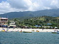 Puerto Galera white beach
 -
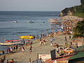
 White Beach from the sea
 -
 White Beach, looking towards the west end
 -
 White Beach at sunset, looking towards the northeast end
 -
 La Laguna Beach, 2005


Saray reperensiya
[dumaen | dumaen so pinanlapuan]- ↑ "2020 Census of Population and Housing (2020 CPH) Population Counts Declared Official by the President". Hulyo 7, 2021. https://psa.gov.ph/content/2020-census-population-and-housing-2020-cph-population-counts-declared-official-president.
- ↑ Census of Population (2015). "Region IV-B (Mimaropa)". Total Population by Province, City, Municipality and Barangay. PSA. Retrieved 29 June 2016.
- ↑ Census of Population and Housing (2010). "Region IV-B (Mimaropa)". Total Population by Province, City, Municipality and Barangay. NSO. Retrieved 29 June 2016.
- ↑ Censuses of Population (1903–2007). "Region IV-B (Mimaropa)". Table 1. Population Enumerated in Various Censuses by Province/Highly Urbanized City: 1903 to 2007. NSO.
Saray gawing ed labas
[dumaen | dumaen so pinanlapuan]- PhilAtlas.com
- Philippine Standard Geographic Code
- Local Governance Performance Management System
- www
.puertogalera .gov .ph

|
Isla ed Tingloy, Look Batangas, Siyudad na Batangas Paso diad Isla ed Verde |
| ||
| Abra de Ilog, Mindoro ed Sagor | San Teodoro | |||
| Mamburao, Mindoro ed Sagor | Santa Cruz, Mindoro ed Sagor |