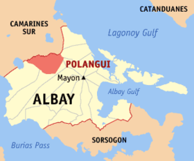
Polangui
Appearance
(Redirected from Polangui, Albay)
Page Module:Infobox/styles.css has no content.
| Polangui | |
|---|---|
| Baley na Filipinas | |
 | |
 Lokasyon na Polangui | |
 | |
| 13°17′32″N 123°29′8″E | |
| Dalin | Filipinas |
| Barangay | 44 |
| Kaawang | |
| • Katiponan | 145.30 km2 (56.10 sq mi) |
| Elebasyon | 59 m (194 ft) |
| Bilang na too (Mayo 1, 2020)[1] | |
| • Katiponan | 89,176 |
| • Densidad | 610/km2 (1,600/sq mi) |
| Economia | |
| • Clase | unaan ya klase ya baley |
| • Ingresos | ₱284,949,421.10 (2020) |
| • Activos | ₱955,170,059.33 (2020) |
| • Pasivos | ₱298,517,169.08 (2020) |
| • Gastos | ₱310,598,550.73 (2020) |
| Kodigo na postal | 4506 |
| Kodigo na lugar | 52 |
| Website | www |
Say Polangui et unaan ya klase ya baley ed luyag na Albay, Filipinas. Unong ed 1 Mayo 2020 census, say populasyon to et 89,176 totoo tan 20,382 abong. Walay kabaleg tan sukat to ya 145.30 sq. km. Say zip code to et 4506.
Saray barangay
[dumaen | dumaen so pinanlapuan]- Agos
- Alnay
- Alomon
- Amoguis
- Anopol
- Apad
- Balaba
- Balangibang
- Balinad
- Basud
- Buyo
- Centro Occidental
- Centro Oriental
- Cepres
- Cotmon
- Cotnogan
- Danao
- Gabon
- Gamot
- Itaran
- Kinuartelan
- La Medalla
- La Purisima
- Lanigay
- Lidong
- Lourdes
- Magpanambo
- Magurang
- Matacon
- Maynaga
- Maysua
- Mendez
- Napo
- Pinagdapugan
- Pintor
- Ponso
- Salvacion
- San Roque
- Santicon
- Sta. Cruz
- Sta. Teresita
- Sugcad
- Ubaliw
Demograpiko
[dumaen | dumaen so pinanlapuan]| Taon | Pop. | ±% p.a. |
|---|---|---|
| 1903 | 7,960 | — |
| 1918 | 13,327 | +3.50% |
| 1939 | 21,086 | +2.21% |
| 1948 | 27,623 | +3.05% |
| 1960 | 38,374 | +2.78% |
| 1970 | 48,586 | +2.38% |
| 1975 | 52,541 | +1.58% |
| 1980 | 55,610 | +1.14% |
| 1990 | 61,556 | +1.02% |
| 1995 | 67,314 | +1.69% |
| 2000 | 70,451 | +0.98% |
| 2007 | 77,122 | +1.26% |
| 2010 | 82,307 | +2.40% |
| 2015 | 88,221 | +1.33% |
| 2020 | 89,176 | +0.21% |
| Reperensiya: Philippine Statistics Authority[2][3][4] | ||
Saray reperensiya
[dumaen | dumaen so pinanlapuan]- ↑ "2020 Census of Population and Housing (2020 CPH) Population Counts Declared Official by the President". Hulyo 7, 2021. https://psa.gov.ph/content/2020-census-population-and-housing-2020-cph-population-counts-declared-official-president.
- ↑ Census of Population (2015). "Region V (Bicol Region)". Total Population by Province, City, Municipality and Barangay. PSA. Retrieved 29 June 2016.
- ↑ Census of Population and Housing (2010). "Region V (Bicol Region)". Total Population by Province, City, Municipality and Barangay. NSO. Retrieved 29 June 2016.
- ↑ Censuses of Population (1903–2007). "Region V (Bicol Region)". Table 1. Population Enumerated in Various Censuses by Province/Highly Urbanized City: 1903 to 2007. NSO.
Saray gawing ed labas
[dumaen | dumaen so pinanlapuan]- PhilAtlas.com
- Philippine Standard Geographic Code
- Local Governance Performance Management System
- www
.polangui .gov .ph
