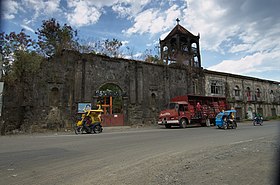
Patnongon
Appearance
Page Module:Infobox/styles.css has no content.
| Patnongon | |
|---|---|
| Baley na Filipinas | |
 | |
 Lokasyon na Patnongon | |
 | |
| 10°54′51″N 121°59′41″E | |
| Dalin | Filipinas |
| Barangay | 36 |
| Kaawang | |
| • Katiponan | 167.92 km2 (64.83 sq mi) |
| Elebasyon | 70 m (230 ft) |
| Bilang na too (Mayo 1, 2020)[1] | |
| • Katiponan | 38,329 |
| • Densidad | 230/km2 (590/sq mi) |
| Economia | |
| • Clase | kumatlo ya klase ya baley |
| • Ingresos | ₱150,468,830.3465,910,919.5973,878,781.8183,063,074.4292,992,271.77103,319,998.35116,964,776.11127,521,203.65135,698,204.90161,067,636.30213,886,597.02 (2020) |
| • Activos | ₱302,636,752.9373,514,784.0583,398,242.4195,238,557.20136,652,697.65146,533,560.77192,276,434.79201,458,134.69244,782,427.77359,360,510.20411,093,990.92 (2020) |
| • Pasivos | ₱24,547,750.979,991,692.699,042,606.9414,017,819.5628,869,703.9423,988,654.8232,932,529.6724,910,269.5018,826,240.8225,470,000.4230,269,425.04 (2020) |
| • Gastos | ₱104,884,807.8455,324,659.4457,621,817.6460,992,594.1467,614,683.4574,450,728.9676,409,469.1396,765,034.3498,276,695.41113,223,079.28149,551,416.70 (2020) |
| Kodigo na postal | 5702 |
| Kodigo na lugar | 36 |
Say Patnongon et kumatlo ya klase ya baley ed luyag na Antique, Filipinas. Unong ed 1 Mayo 2020 census, say populasyon to et 38,329 totoo tan 9,785 abong. Walay kabaleg tan sukat to ya 167.92 sq. km. Say zip code to et 5702.
Saray barangay
[dumaen | dumaen so pinanlapuan]- Alvañiz
- Amparo
- Apgahan
- Aureliana
- Badiangan
- Bitas
- Carit-an
- Cuyapiao
- Villa Elio
- Gella
- Igbarawan
- Igbobon
- Igburi
- La-Rioja
- Mabasa
- Macarina
- Magarang
- Magsaysay
- Padang
- Pandanan
- Patlabawon
- Poblacion
- Quezon
- Salaguiawan
- Samalague
- San Rafael
- Tobias Fornier
- Tamayoc
- Tigbalogo
- Villa Crespo
- Villa Cruz
- Villa Flores
- Villa Laua-an
- Villa Sal
- Villa Salomon
- Vista Alegre
Demograpiko
[dumaen | dumaen so pinanlapuan]| Taon | Pop. | ±% p.a. |
|---|---|---|
| 1903 | 14,319 | — |
| 1918 | 15,721 | +0.62% |
| 1939 | 20,012 | +1.16% |
| 1948 | 23,145 | +1.63% |
| 1960 | 23,207 | +0.02% |
| 1970 | 22,443 | −0.33% |
| 1975 | 22,643 | +0.18% |
| 1980 | 24,262 | +1.39% |
| 1990 | 27,376 | +1.22% |
| 1995 | 29,235 | +1.24% |
| 2000 | 31,555 | +1.65% |
| 2007 | 33,694 | +0.91% |
| 2010 | 35,102 | +1.50% |
| 2015 | 37,176 | +1.10% |
| 2020 | 38,329 | +0.60% |
| Reperensiya: Philippine Statistics Authority[2][3][4] | ||
Saray reperensiya
[dumaen | dumaen so pinanlapuan]- ↑ "2020 Census of Population and Housing (2020 CPH) Population Counts Declared Official by the President". Hulyo 7, 2021. https://psa.gov.ph/content/2020-census-population-and-housing-2020-cph-population-counts-declared-official-president.
- ↑ Census of Population (2015). "Region VI (Western Visayas)". Total Population by Province, City, Municipality and Barangay. PSA. Retrieved 29 June 2016.
- ↑ Census of Population and Housing (2010). "Region VI (Western Visayas)". Total Population by Province, City, Municipality and Barangay. NSO. Retrieved 29 June 2016.
- ↑ Censuses of Population (1903–2007). "Region VI (Western Visayas)". Table 1. Population Enumerated in Various Censuses by Province/Highly Urbanized City: 1903 to 2007. NSO.
Saray gawing ed labas
[dumaen | dumaen so pinanlapuan]
