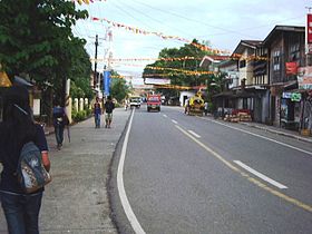
Nasipit
Appearance
| Nasipit | |
|---|---|
| Baley na Filipinas | |
 | |
 Lokasyon na Nasipit | |
 | |
| 8°59′24″N 125°20′24″E | |
| Dalin | Filipinas |
| Angipaletnegan | Agosto 1, 1929 |
| Barangay | 19 |
| Kaawang[1] | |
| • Katiponan | 144.4 km2 (55.8 sq mi) |
| Elebasyon | 31 m (102 ft) |
| Bilang na too (Mayo 1, 2020)[2] | |
| • Katiponan | 44,822 |
| • Densidad | 310/km2 (800/sq mi) |
| Economia | |
| • Clase | kumatlo ya klase ya baley |
| • Ingresos | ₱170,132,428.6671,335,933.3581,488,200.3498,808,899.66114,234,406.95129,838,386.51142,450,707.77143,453,421.10155,249,707.42179,894,037.45243,067,028.54 (2020) |
| • Activos | ₱317,281,695.0573,952,921.6492,879,188.11123,570,415.21198,716,026.33177,546,385.57206,380,030.93241,927,632.14261,610,726.11348,135,457.05386,751,929.13 (2020) |
| • Pasivos | ₱67,075,302.5626,072,812.7439,080,763.1659,629,061.46111,295,355.2886,263,071.0892,847,439.92124,746,803.0976,494,995.6153,711,693.8857,488,768.54 (2020) |
| • Gastos | ₱178,727,165.5959,819,791.6563,505,956.4872,019,977.2595,529,248.70129,647,839.46126,995,558.69137,299,008.82153,730,941.77157,777,497.66210,215,140.15 (2020) |
| Kodigo na postal | 8602 |
| Kodigo na lugar | 85 |
| Website |
www |
Say Nasipit et kumatlo ya klase ya baley ed luyag na Agusan ed Baybay, Filipinas. Unong ed 1 Mayo 2020 census, say populasyon to et 44,822 totoo tan 10,580 abong. Walay kabaleg tan sukat to ya 144.4 sq. km. Say zip code to et 8602.
Saray barangay
[dumaen | dumaen so pinanlapuan]- Aclan
- Amontay
- Ata-atahon
- Camagong
- Cubi-cubi
- Culit
- Jaguimitan
- Kinabjangan
- Barangay 1 (Poblacion)
- Barangay 2 (Poblacion)
- Barangay 3 (Poblacion)
- Barangay 4 (Poblacion)
- Barangay 5 (Poblacion)
- Barangay 6 (Poblacion)
- Barangay 7 (Poblacion)
- Punta
- Santa Ana
- Talisay
- Triangulo
Demograpiko
[dumaen | dumaen so pinanlapuan]| Taon | Pop. | ±% p.a. |
|---|---|---|
| 1903 | 611 | — |
| 1939 | 8,529 | +7.60% |
| 1948 | 12,502 | +4.34% |
| 1960 | 14,996 | +1.53% |
| 1970 | 23,306 | +4.50% |
| 1975 | 25,289 | +1.65% |
| 1980 | 29,905 | +3.41% |
| 1990 | 34,084 | +1.32% |
| 1995 | 34,255 | +0.09% |
| 2000 | 35,817 | +0.96% |
| 2007 | 38,096 | +0.85% |
| 2010 | 40,663 | +2.40% |
| 2015 | 41,957 | +0.60% |
| 2020 | 44,822 | +1.31% |
| Reperensiya: Philippine Statistics Authority[3][4][5] | ||
Saray reperensiya
[dumaen | dumaen so pinanlapuan]- ↑ Error: Unable to display the reference properly. See the documentation for details.
- ↑ "2020 Census of Population and Housing (2020 CPH) Population Counts Declared Official by the President". Hulyo 7, 2021. https://psa.gov.ph/content/2020-census-population-and-housing-2020-cph-population-counts-declared-official-president.
- ↑ Census of Population (2015). "Caraga". Total Population by Province, City, Municipality and Barangay. PSA. Retrieved 29 June 2016.
- ↑ Census of Population and Housing (2010). "Caraga". Total Population by Province, City, Municipality and Barangay. NSO. Retrieved 29 June 2016.
- ↑ Censuses of Population (1903–2007). "Caraga". Table 1. Population Enumerated in Various Censuses by Province/Highly Urbanized City: 1903 to 2007. NSO.
Saray gawing ed labas
[dumaen | dumaen so pinanlapuan]- PhilAtlas.com
- Philippine Standard Geographic Code
- Local Governance Performance Management System
- www
.nasipitsite .com
