Mahinog
Appearance
| Mahinog | |
|---|---|
| Baley na Filipinas | |
 | |
 Lokasyon na Mahinog | |
 | |
| 9°9′0″N 124°46′48″E | |
| Dalin | Filipinas |
| Angipaletnegan | Setyembre 14, 1869 |
| Barangay | 13 |
| Kaawang | |
| • Katiponan | 32.55 km2 (12.57 sq mi) |
| Elebasyon | 47 m (154 ft) |
| Bilang na too (Mayo 1, 2020)[1] | |
| • Katiponan | 14,634 |
| • Densidad | 450/km2 (1,200/sq mi) |
| Economia | |
| • Clase | kumalima ya klase ya baley |
| • Ingresos | ₱112,580,492.0034,807,785.3938,610,463.1544,038,209.6552,386,639.0058,951,471.0064,271,446.0070,319,635.0078,036,735.00103,397,178.00122,919,547.00 (2020) |
| • Activos | ₱233,665,608.0057,417,922.7451,376,232.6261,343,161.2475,626,452.0094,275,848.00137,017,215.00169,809,924.00217,163,095.00285,070,282.00319,180,068.00 (2020) |
| • Pasivos | ₱33,637,119.0012,779,948.929,946,488.6416,682,120.1828,417,673.0032,702,384.0042,097,010.0041,487,453.0047,945,586.0081,432,827.0088,472,101.00 (2020) |
| • Gastos | ₱88,173,634.0034,406,457.5837,433,436.4941,132,174.8243,790,702.0052,570,003.0052,866,731.0058,290,673.0073,944,916.0087,577,293.0096,889,357.00 (2020) |
| Kodigo na postal | 9101 |
| Kodigo na lugar | 88 |
| Website |
www |
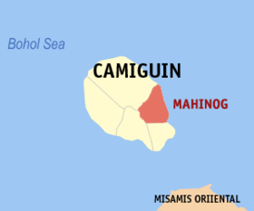
Say Mahinog et kumalima ya klase ya baley ed luyag na Camiguin, Filipinas. Unong ed 1 Mayo 2020 census, say populasyon to et 14,634 totoo tan 3,502 abong. Walay kabaleg tan sukat to ya 32.55 sq. km. Say zip code to et 9101.
Saray barangay
[dumaen | dumaen so pinanlapuan]- Benoni
- Binaliwan
- Catohugan
- Hubangon
- Owakan
- Poblacion
- Puntod
- San Isidro
- San Jose
- San Miguel
- San Roque
- Tacangon
- Tubod
- Tupsan Pequeño
Demograpiko
[dumaen | dumaen so pinanlapuan]| Taon | Pop. | ±% p.a. |
|---|---|---|
| 1903 | 5,727 | — |
| 1948 | 9,500 | +1.13% |
| 1960 | 7,719 | −1.71% |
| 1970 | 8,999 | +1.54% |
| 1980 | 9,993 | +1.05% |
| 1990 | 11,313 | +1.25% |
| 1995 | 11,351 | +0.06% |
| 2000 | 12,592 | +2.25% |
| 2007 | 13,168 | +0.62% |
| 2010 | 13,531 | +0.99% |
| 2015 | 14,038 | +0.70% |
| 2020 | 14,634 | +0.82% |
| Reperensiya: Philippine Statistics Authority[2][3][4] | ||
Saray reperensiya
[dumaen | dumaen so pinanlapuan]- ↑ "2020 Census of Population and Housing (2020 CPH) Population Counts Declared Official by the President". Hulyo 7, 2021. https://psa.gov.ph/content/2020-census-population-and-housing-2020-cph-population-counts-declared-official-president.
- ↑ Census of Population (2015). "Region X (Northern Mindanao)". Total Population by Province, City, Municipality and Barangay. PSA. Retrieved 29 June 2016.
- ↑ Census of Population and Housing (2010). "Region X (Northern Mindanao)". Total Population by Province, City, Municipality and Barangay. NSO. Retrieved 29 June 2016.
- ↑ Censuses of Population (1903–2007). "Region X (Northern Mindanao)". Table 1. Population Enumerated in Various Censuses by Province/Highly Urbanized City: 1903 to 2007. NSO.
Saray gawing ed labas
[dumaen | dumaen so pinanlapuan]- PhilAtlas.com
- Philippine Standard Geographic Code
- Local Governance Performance Management System
- www
.mahinogcamiguin .gov .ph
