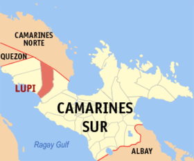
Lupi
Appearance
Page Module:Infobox/styles.css has no content.
| Lupi | |
|---|---|
| Baley na Filipinas | |
 Lokasyon na Lupi | |
 | |
| 13°47′27″N 122°54′33″E | |
| Dalin | Filipinas |
| Barangay | 38 |
| Kaawang | |
| • Katiponan | 199.12 km2 (76.88 sq mi) |
| Elebasyon | 81 m (266 ft) |
| Bilang na too (Mayo 1, 2020)[1] | |
| • Katiponan | 33,897 |
| • Densidad | 170/km2 (440/sq mi) |
| Economia | |
| • Clase | kumatlo ya klase ya baley |
| • Ingresos | ₱153,207,351.4760,198,009.3768,253,227.5077,440,587.9988,043,680.1897,281,758.85110,251,276.27117,391,106.92127,235,505.69152,560,655.43205,971,567.85 (2020) |
| • Activos | ₱335,369,195.8278,539,859.6690,227,170.11117,267,688.7222,489,928.48150,391,607.98216,006,936.07284,211,202.59315,099,144.28373,274,053.23512,890,260.03 (2020) |
| • Pasivos | ₱59,701,561.4729,051,790.6132,066,275.5835,996,311.0644,816,372.4044,812,680.4954,590,181.3384,699,114.7876,606,305.9455,045,609.32132,465,417.93 (2020) |
| • Gastos | ₱112,363,736.0048,353,337.7847,235,526.2151,347,197.9663,960,551.2170,087,862.3573,189,780.8778,090,937.5089,327,680.47106,091,626.01125,344,214.56 (2020) |
| Kodigo na postal | 4409 |
| Kodigo na lugar | 54 |
Say Lupi et kumatlo ya klase ya baley ed luyag na Camarines ed Abalaten, Filipinas. Unong ed 1 Mayo 2020 census, say populasyon to et 33,897 totoo tan 8,256 abong. Walay kabaleg tan sukat to ya 199.12 sq. km. Say zip code to et 4409.
Saray barangay
[dumaen | dumaen so pinanlapuan]- Alleomar
- Bagangan Sr.
- Bagong Sikat
- Bel-Cruz
- Bangon
- Barrera Jr.
- Barrera Sr.
- Belwang
- Buenasuerte
- Bulawan Jr.
- Bulawan Sr.
- Cabutagan
- Kaibigan
- Casay
- Colacling (Del Rosario)
- Cristo Rey
- Del Carmen
- Haguimit
- Haluban (Pigbasagan)
- La Purisima
- Lourdes
- Mangcawayan
- Napolidan
- Poblacion
- Polantuna
- Sagrada
- Salvacion
- San Isidro
- San Jose
- San Pedro
- San Rafael Norte
- San Rafael Sur
- San Ramon
- San Vicente
- Sooc
- Tanawan
- Tible
- Tapi (Lupi Nuevo)
Demograpiko
[dumaen | dumaen so pinanlapuan]| Taon | Pop. | ±% p.a. |
|---|---|---|
| 1903 | 1,307 | — |
| 1918 | 1,515 | +0.99% |
| 1939 | 3,455 | +4.00% |
| 1948 | 6,513 | +7.30% |
| 1960 | 16,981 | +8.31% |
| 1970 | 18,419 | +0.82% |
| 1975 | 19,682 | +1.34% |
| 1980 | 21,216 | +1.51% |
| 1990 | 24,809 | +1.58% |
| 1995 | 25,390 | +0.43% |
| 2000 | 26,148 | +0.63% |
| 2007 | 27,630 | +0.76% |
| 2010 | 30,118 | +3.19% |
| 2015 | 32,167 | +1.26% |
| 2020 | 33,897 | +1.04% |
| Reperensiya: Philippine Statistics Authority[2][3][4] | ||
Saray reperensiya
[dumaen | dumaen so pinanlapuan]- ↑ "2020 Census of Population and Housing (2020 CPH) Population Counts Declared Official by the President". Hulyo 7, 2021. https://psa.gov.ph/content/2020-census-population-and-housing-2020-cph-population-counts-declared-official-president.
- ↑ Census of Population (2015). "Region V (Bicol Region)". Total Population by Province, City, Municipality and Barangay. PSA. Retrieved 29 June 2016.
- ↑ Census of Population and Housing (2010). "Region V (Bicol Region)". Total Population by Province, City, Municipality and Barangay. NSO. Retrieved 29 June 2016.
- ↑ Censuses of Population (1903–2007). "Region V (Bicol Region)". Table 1. Population Enumerated in Various Censuses by Province/Highly Urbanized City: 1903 to 2007. NSO.
Saray gawing ed labas
[dumaen | dumaen so pinanlapuan]
