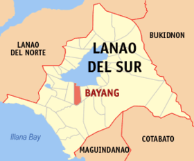
Bayang
Appearance
| Bayang | |
|---|---|
| Baley na Filipinas | |
 Lokasyon na Bayang | |
 | |
| 7°47′35″N 124°11′31″E | |
| Dalin | Filipinas |
| Barangay | 49 |
| Kaawang | |
| • Katiponan | 230.00 km2 (88.80 sq mi) |
| Elebasyon | 780 m (2,560 ft) |
| Bilang na too (Mayo 1, 2020)[1] | |
| • Katiponan | 28,023 |
| • Densidad | 120/km2 (320/sq mi) |
| Economia | |
| • Clase | kumalima ya klase ya baley |
| • Ingresos | ₱110,460,286.00 (2020) |
| • Activos | ₱94,821,457.03 (2020) |
| • Pasivos | ₱61,174,200.38 (2020) |
| • Gastos | ₱105,322,588.65 (2020) |
| Kodigo na postal | 9309 |
| Kodigo na lugar | 63 |
| Website |
www |
Say Bayang et kumalima ya klase ya baley ed luyag na Lanao del Sur, Filipinas. Unong ed 1 Mayo 2020 census, say populasyon to et 28,023 totoo tan 4,085 abong. Walay kabaleg tan sukat to ya 230.00 sq. km. Say zip code to et 9309.
Saray barangay
[dumaen | dumaen so pinanlapuan]- Bagoaingud
- Bairan (Pob.)
- Bandingun
- Biabi
- Bialaan
- Cadayonan
- Lumbac Cadayonan
- Lalapung Central
- Condaraan Pob. (Condaraan Dim)
- Cormatan
- Ilian
- Lalapung Proper (Pob.)
- Bubong Lilod
- Linao
- Linuk (Pob.)
- Liong
- Lumbac
- Mimbalawag
- Maliwanag
- Mapantao
- Cadingilan Occidental
- Cadingilan Oriental
- Palao
- Pama-an
- Pamacotan
- Pantar
- Parao
- Patong
- Porotan
- Rantian
- Raya Cadayonan
- Rinabor (Pob.)
- Sapa
- Samporna (Pob.)
- Silid
- Sugod
- Sultan Pandapatan
- Sumbag (Pob.)
- Tagoranao
- Tangcal
- Tangcal Proper (Pob.)
- Tuca (Pob.)
- Tomarompong
- Tomongcal Ligi
- Torogan
- Lalapung Upper
- Gandamato
- Bubong Raya
- Poblacion (Bayang)
Demograpiko
[dumaen | dumaen so pinanlapuan]| Taon | Pop. | ±% p.a. |
|---|---|---|
| 1918 | 1,982 | — |
| 1939 | 4,480 | +3.96% |
| 1948 | 4,817 | +0.81% |
| 1960 | 24,315 | +14.44% |
| 1970 | 23,772 | −0.23% |
| 1975 | 19,455 | −3.94% |
| 1980 | 18,811 | −0.67% |
| 1990 | 18,928 | +0.06% |
| 1995 | 20,060 | +1.09% |
| 2000 | 21,020 | +1.01% |
| 2007 | 24,185 | +1.95% |
| 2010 | 21,472 | −4.24% |
| 2015 | 23,965 | +2.11% |
| 2020 | 28,023 | +3.12% |
| Reperensiya: Philippine Statistics Authority[2][3][4] | ||
Saray reperensiya
[dumaen | dumaen so pinanlapuan]- ↑ "2020 Census of Population and Housing (2020 CPH) Population Counts Declared Official by the President". Hulyo 7, 2021. https://psa.gov.ph/content/2020-census-population-and-housing-2020-cph-population-counts-declared-official-president.
- ↑ Census of Population (2015). "ARMM – Autonomous Region in Muslim Mindanao". Total Population by Province, City, Municipality and Barangay. PSA. Retrieved 29 June 2016.
- ↑ Census of Population and Housing (2010). "ARMM – Autonomous Region in Muslim Mindanao". Total Population by Province, City, Municipality and Barangay. NSO. Retrieved 29 June 2016.
- ↑ Censuses of Population (1903–2007). "ARMM – Autonomous Region in Muslim Mindanao". Table 1. Population Enumerated in Various Censuses by Province/Highly Urbanized City: 1903 to 2007. NSO.
Saray gawing ed labas
[dumaen | dumaen so pinanlapuan]- PhilAtlas.com
- Philippine Standard Geographic Code
- Local Governance Performance Management System
- www
.bayang-lds .gov .ph
