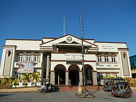
Orani
Appearance
| Orani | ||
|---|---|---|
| Baley na Filipinas | ||
 | ||
| ||
 Lokasyon na Orani | ||
 | ||
| 14°48′0″N 120°31′48″E | ||
| Dalin | Filipinas | |
| Angipaletnegan | 1891 | |
| Barangay | 29 | |
| Kaawang | ||
| • Katiponan | 64.90 km2 (25.06 sq mi) | |
| Elebasyon | 14 m (46 ft) | |
| Bilang na too (Mayo 1, 2020)[1] | ||
| • Katiponan | 70,342 | |
| • Densidad | 1,100/km2 (2,800/sq mi) | |
| Economia | ||
| • Clase | unaan ya klase ya baley | |
| • Ingresos | ₱273,773,378.58113,805,245.23126,948,462.45141,218,086.04156,047,990.68171,851,783.37195,398,769.40219,910,927.28236,338,068.53274,969,766.85349,845,588.62 (2020) | |
| • Activos | ₱526,529,874.36185,172,843.77234,797,181.07275,773,182.64341,424,027.68407,689,672.71402,743,057.21429,997,279.00512,858,669.71476,443,166.12500,295,487.09 (2020) | |
| • Pasivos | ₱274,878,431.2042,860,398.1882,115,810.3191,185,187.04136,667,408.60192,390,727.19165,432,142.46189,390,944.39265,222,818.23255,144,746.59257,136,331.41 (2020) | |
| • Gastos | ₱290,920,814.85102,709,509.65104,283,367.92101,634,171.99138,437,568.05163,455,842.77173,957,152.66221,355,287.49243,172,224.77275,164,831.44334,297,945.81 (2020) | |
| Kodigo na postal | 2108 | |
| Kodigo na lugar | 47 | |
Say Orani et unaan ya klase ya baley ed luyag na Bataan, Filipinas. Unong ed 1 Mayo 2020 census, say populasyon to et 70,342 totoo tan 17,524 abong. Walay kabaleg tan sukat to ya 64.90 sq. km. Say zip code to et 2108.
Saray barangay
[dumaen | dumaen so pinanlapuan]Say Orani walay 33 ya barangay.
- Alikabok
- Apollo Village (Apollo)
- Bagong Paraiso (Pob.)
- Balut (Pob.)
- Bayan (Pob.)
- Calero (Pob.)
- Carbonero (Pob.)
- Centro I/Poblacion
- Centro II (Pob.)
- Doña
- Kabalutan
- Kaparangan
- Maria Fe Subdivision
- Masantol
- Mulawin
- Pacar
- Pag-asa
- Palihan (Pob.)
- Pantalan Bago (Pob.)
- Pantalan Luma (Pob.)
- Parang Parang (Pob.)
- St. Joseph Subdivision
- Puksuan
- Sibul
- Silahis
- Tala
- Talahib
- Talimundoc
- Tagumpay
- Tapulao
- Tenejero (Pob.)
- Tugatog
- Wawa (Pob.)
Demograpiko
[dumaen | dumaen so pinanlapuan]| Taon | Pop. | ±% p.a. |
|---|---|---|
| 1903 | 5,787 | — |
| 1918 | 6,381 | +0.65% |
| 1939 | 9,658 | +1.99% |
| 1948 | 12,718 | +3.11% |
| 1960 | 17,618 | +2.75% |
| 1970 | 25,740 | +3.86% |
| 1975 | 29,464 | +2.75% |
| 1980 | 33,083 | +2.34% |
| 1990 | 43,494 | +2.77% |
| 1995 | 48,695 | +2.14% |
| 2000 | 52,501 | +1.63% |
| 2007 | 59,530 | +1.75% |
| 2010 | 61,099 | +0.95% |
| 2015 | 66,909 | +1.75% |
| 2020 | 70,342 | +0.99% |
| Reperensiya: Philippine Statistics Authority[2][3][4] | ||
Saray reperensiya
[dumaen | dumaen so pinanlapuan]- ↑ "2020 Census of Population and Housing (2020 CPH) Population Counts Declared Official by the President". Hulyo 7, 2021. https://psa.gov.ph/content/2020-census-population-and-housing-2020-cph-population-counts-declared-official-president.
- ↑ Census of Population (2015). "Region III (Central Luzon)". Total Population by Province, City, Municipality and Barangay. PSA. Retrieved 29 June 2016.
- ↑ Census of Population and Housing (2010). "Region III (Central Luzon)". Total Population by Province, City, Municipality and Barangay. NSO. Retrieved 29 June 2016.
- ↑ Censuses of Population (1903–2007). "Region III (Central Luzon)". Table 1. Population Enumerated in Various Censuses by Province/Highly Urbanized City: 1903 to 2007. NSO.
Saray gawing ed labas
[dumaen | dumaen so pinanlapuan]

