
File:Ilokano language map.png
Size of this preview: 384 × 599 pixels. Other resolutions: 154 × 240 pixels | 308 × 480 pixels | 492 × 768 pixels | 656 × 1,024 pixels | 2,000 × 3,120 pixels.
Original file (2,000 × 3,120 pixels, file size: 394 KB, MIME type: image/png)

|
This linguistic map image could be re-created using vector graphics as an SVG file. This has several advantages; see Commons:Media for cleanup for more information. If an SVG form of this image is available, please upload it and afterwards replace this template with
{{vector version available|new image name}}.
It is recommended to name the SVG file “Ilokano language map.svg”—then the template Vector version available (or Vva) does not need the new image name parameter. |
Sumaryo
| Deskripsion |
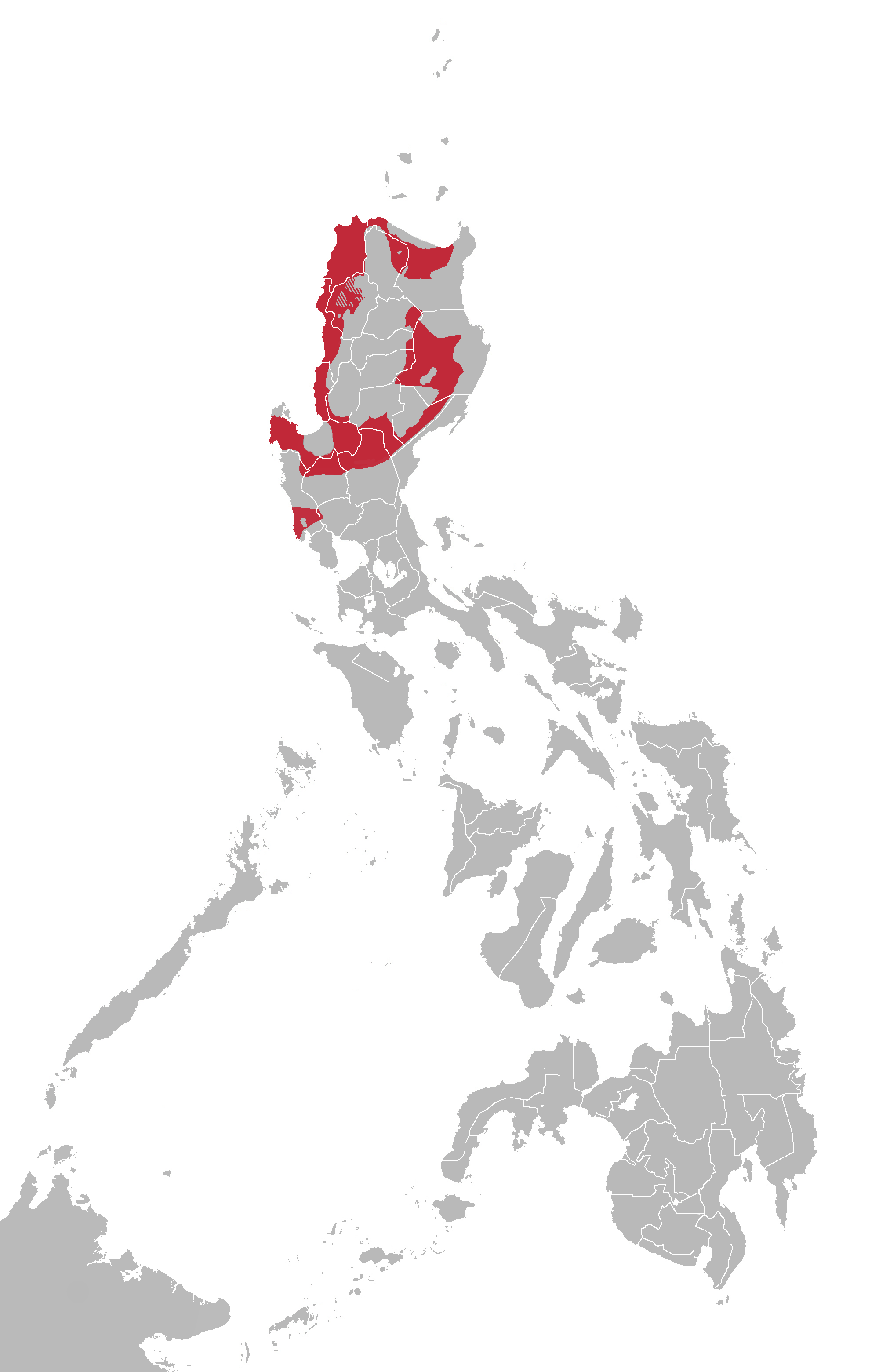
English: Ilokano language map based on Ethnologue |
| Agew | |
| Pinanlapuan | Derivative work of BlankMap-Philippines.png by User:TheCoffee |
| Autor | Pansitkanton |
Licensing
I, the copyright holder of this work, hereby publish it under the following license:
This file is licensed under the Creative Commons Attribution-Share Alike 3.0 Unported license.
- You are free:
- to share – to copy, distribute and transmit the work
- to remix – to adapt the work
- Under the following conditions:
- attribution – You must give appropriate credit, provide a link to the license, and indicate if changes were made. You may do so in any reasonable manner, but not in any way that suggests the licensor endorses you or your use.
- share alike – If you remix, transform, or build upon the material, you must distribute your contributions under the same or compatible license as the original.
File history
Click on a date/time to view the file as it appeared at that time.
| Agew/Oras | Thumbnail | Dimensions | Manguusar | Komento | |
|---|---|---|---|---|---|
| kaplesan | 17:51, 26 Oktubre 2013 | | 2,000 × 3,120 (394 KB) | Pansitkanton | Added Ilokano-speaking areas in Abra province |
| 21:19, 25 Oktubre 2013 |  | 2,000 × 3,120 (391 KB) | Pansitkanton | Added Ilokano-speaking area in Zambales province | |
| 17:15, 25 Oktubre 2013 |  | 2,000 × 3,120 (391 KB) | Pansitkanton | Further made shape and borders accurate based on Ethnologue outline | |
| 13:04, 19 Oktubre 2013 |  | 2,000 × 3,120 (387 KB) | Pansitkanton | Further refined island details | |
| 20:41, 18 Oktubre 2013 |  | 2,000 × 3,120 (111 KB) | Pansitkanton | refined lines and slightly modified the range | |
| 14:27, 18 Oktubre 2013 |  | 2,000 × 3,120 (116 KB) | Pansitkanton | User created page with UploadWizard |
Saray Gawing
The following page uses this file:
Global file usage
The following other wikis use this file:
- Usage on af.wikipedia.org
- Usage on am.wikipedia.org
- Usage on azb.wikipedia.org
- Usage on bcl.wikipedia.org
- Usage on bn.wikipedia.org
- Usage on cdo.wikipedia.org
- Usage on ceb.wikipedia.org
- Usage on cs.wikipedia.org
- Usage on en.wikipedia.org
- Usage on en.wikibooks.org
- Usage on es.wikipedia.org
- Usage on fa.wikipedia.org
- Usage on gl.wikipedia.org
- Usage on hi.wikipedia.org
- Usage on ilo.wikipedia.org
- Usage on jv.wikipedia.org
- Usage on ka.wikipedia.org
- Usage on ko.wikipedia.org
- Usage on kv.wikipedia.org
- Usage on lij.wikipedia.org
- Usage on lv.wikipedia.org
- Usage on oc.wikipedia.org
- Usage on pl.wikipedia.org
- Usage on pt.wikipedia.org
- Usage on ru.wikipedia.org
- Usage on sat.wikipedia.org
- Usage on sw.wikipedia.org
- Usage on th.wikipedia.org
- Usage on tl.wikipedia.org
- Usage on uk.wikipedia.org
- Usage on vi.wikipedia.org
- Usage on zh-min-nan.wikipedia.org