
File:EU-Malta.svg

Size of this PNG preview of this SVG file: 713 × 600 pixels. Other resolutions: 285 × 240 pixels | 571 × 480 pixels | 913 × 768 pixels | 1,218 × 1,024 pixels | 2,435 × 2,048 pixels | 2,045 × 1,720 pixels.
Original file (SVG file, nominally 2,045 × 1,720 pixels, file size: 2.12 MB)
Sumaryo
| Deskripsion |
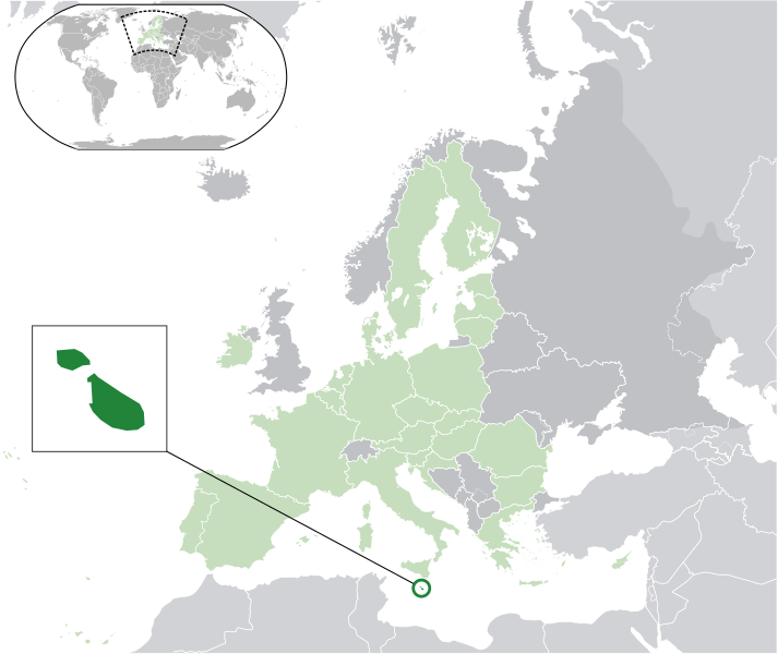
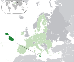
English: (Dark-Green) Malta. (Light-Green) The rest of the European Union (EU). (Dark-gray) The rest of Europe. (Light-gray) The surrounding region.
See also: |
| SVG genesis | |
| Agew | |
| Pinanlapuan | Own work based on: Location European nation states.svg |
| Autor | NuclearVacuum |
| Other versions |
Licensing
I, the copyright holder of this work, hereby publish it under the following licenses:
This file is licensed under the Creative Commons Attribution-Share Alike 3.0 Unported license.
- You are free:
- to share – to copy, distribute and transmit the work
- to remix – to adapt the work
- Under the following conditions:
- attribution – You must give appropriate credit, provide a link to the license, and indicate if changes were made. You may do so in any reasonable manner, but not in any way that suggests the licensor endorses you or your use.
- share alike – If you remix, transform, or build upon the material, you must distribute your contributions under the same or compatible license as the original.

|
Permission is granted to copy, distribute and/or modify this document under the terms of the GNU Free Documentation License, Version 1.2 or any later version published by the Free Software Foundation; with no Invariant Sections, no Front-Cover Texts, and no Back-Cover Texts. A copy of the license is included in the section entitled GNU Free Documentation License. |
You may select the license of your choice.
File history
Click on a date/time to view the file as it appeared at that time.
| Agew/Oras | Thumbnail | Dimensions | Manguusar | Komento | |
|---|---|---|---|---|---|
| kaplesan | 22:55, 11 Hulyo 2020 | | 2,045 × 1,720 (2.12 MB) | De728631 | Plus South Sudan in World map |
| 14:12, 1 Pebrero 2020 |  | 2,045 × 1,720 (2.03 MB) | Thom.lanaud | Minus the UK | |
| 07:29, 14 Disyembre 2015 |  | 2,045 × 1,720 (2.63 MB) | Nicolay Sidorov | fix disputed borders | |
| 22:34, 14 Mayo 2015 |  | 2,045 × 1,720 (2.64 MB) | Elianfoo | Scaled circle so that Sicily is not inside | |
| 09:26, 1 Hulyo 2013 |  | 2,045 × 1,720 (2.61 MB) | U5K0 | croatia | |
| 15:03, 23 Oktubre 2009 |  | 2,045 × 1,720 (2.59 MB) | NuclearVacuum | consensus version | |
| 19:01, 18 Oktubre 2009 |  | 2,045 × 1,720 (2.62 MB) | NuclearVacuum | minor | |
| 18:55, 18 Oktubre 2009 |  | 2,045 × 1,720 (2.62 MB) | NuclearVacuum | final version | |
| 17:51, 17 Oktubre 2009 |  | 680 × 520 (530 KB) | NuclearVacuum | new | |
| 16:34, 17 Oktubre 2009 |  | 680 × 520 (527 KB) | NuclearVacuum | {{Information |Description={{en|1={{EU-SVG-en|Malta}}}} |Source=*File:Blank map europe.svg<br>{{Inkscape}} |Author=NuclearVacuum |Date=2009-10 |Permission= |other_versions=*File:Location Malta EU Europe.png }} [[Category: |
Saray Gawing
The following page uses this file:
Global file usage
The following other wikis use this file:
- Usage on af.wikipedia.org
- Usage on als.wikipedia.org
- Usage on ami.wikipedia.org
- Usage on ar.wikipedia.org
- مالطا
- بوابة:مالطا
- بوابة:مالطا/واجهة
- بلديات مالطا (المجالس المحلية لمالطا)
- مستخدم:ElWaliElAlaoui/ملعب 8
- معاملة المثليين في مالطا
- مستخدم:جار الله/قائمة صور مقالات العلاقات الثنائية
- العلاقات الأمريكية المالطية
- العلاقات الأنغولية المالطية
- العلاقات الكورية الجنوبية المالطية
- العلاقات الإريترية المالطية
- العلاقات السويسرية المالطية
- العلاقات الألمانية المالطية
- العلاقات الليختنشتانية المالطية
- العلاقات البوليفية المالطية
- العلاقات المالطية الموزمبيقية
- العلاقات الألبانية المالطية
- العلاقات البلجيكية المالطية
- العلاقات الإثيوبية المالطية
- العلاقات البيلاروسية المالطية
- العلاقات الطاجيكستانية المالطية
- العلاقات الروسية المالطية
- العلاقات الرومانية المالطية
- العلاقات الأرجنتينية المالطية
- العلاقات الغامبية المالطية
- العلاقات القبرصية المالطية
- العلاقات السيراليونية المالطية
- العلاقات المالطية النيبالية
- العلاقات الليبيرية المالطية
- العلاقات التشيكية المالطية
- العلاقات المالطية الميانمارية
- العلاقات العراقية المالطية
- العلاقات البريطانية المالطية
- العلاقات الكندية المالطية
- العلاقات الكوبية المالطية
- العلاقات الكورية الشمالية المالطية
- العلاقات الكوستاريكية المالطية
- العلاقات الكولومبية المالطية
- العلاقات الكيريباتية المالطية
- العلاقات الكينية المالطية
- العلاقات اللاتفية المالطية
- العلاقات اللاوسية المالطية
- العلاقات اللبنانية المالطية
- العلاقات اللوكسمبورغية المالطية
- العلاقات الليبية المالطية
- العلاقات الليتوانية المالطية
View more global usage of this file.