
File:ArmeniaNumbered.png
Size of this preview: 594 × 600 pixels. Other resolutions: 238 × 240 pixels | 476 × 480 pixels | 750 × 757 pixels.
Original file (750 × 757 pixels, file size: 81 KB, MIME type: image/png)

|
File:Armenia map numbered.svg is a vector version of this file. It should be used in place of this PNG file.
File:ArmeniaNumbered.png → File:Armenia map numbered.svg
For more information, see Help:SVG. |
 |
Sumaryo
Español: Mapa de las provincias de Armenia.
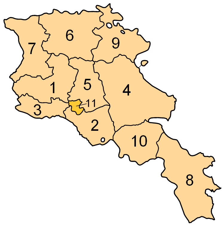
Subdivisions of Armenia. Map created by w:en:user:Golbez. Coloured by w:en:user:Aivazovsky.
Licensing

|
Permission is granted to copy, distribute and/or modify this document under the terms of the GNU Free Documentation License, Version 1.2 or any later version published by the Free Software Foundation; with no Invariant Sections, no Front-Cover Texts, and no Back-Cover Texts. A copy of the license is included in the section entitled GNU Free Documentation License. |
| This file is licensed under the Creative Commons Attribution-Share Alike 3.0 Unported license. | ||
| ||
| This licensing tag was added to this file as part of the GFDL licensing update. |
Image shows the eleven administrative subdivisions of Armenia:
- Aragatsotn (Արագածոտնի)
- Ararat (Արարատի)
- Armavir (Արմավիրի)
- Gegharkunik (Գեղարքունիքի)
- Kotayk (Կոտայքի)
- Lori (Լոռու)
- Shirak (Շիրակի)
- Syunik (Սյունիքի)
- Tavush (Տավուշի)
- Vayots Dzor (Վայոց Ձորի)
- Yerevan (Երևան) - special administrative status
File history
Click on a date/time to view the file as it appeared at that time.
| Agew/Oras | Thumbnail | Dimensions | Manguusar | Komento | |
|---|---|---|---|---|---|
| kaplesan | 17:18, 13 Oktubre 2013 | | 750 × 757 (81 KB) | Fry1989 | Per AN, this type of POV is improper and unacceptable |
| 20:05, 11 Oktubre 2013 |  | 750 × 757 (67 KB) | Ankax Hayastan | Reverted to version as of 16:47, 9 September 2010 | |
| 20:00, 11 Oktubre 2013 |  | 750 × 757 (81 KB) | Fry1989 | Revert political POV | |
| 16:47, 9 Setyembre 2010 |  | 750 × 757 (67 KB) | Ankax Hayastan | ((Exclaves deleted according to official map at http://www.gov.am/en/regions/)) | |
| 16:41, 9 Setyembre 2010 |  | 750 × 757 (67 KB) | Ankax Hayastan | ((Exclaves deleted according to official map at http://www.gov.am/en/regions/)) | |
| 01:57, 30 Hulyo 2006 |  | 750 × 757 (81 KB) | Aivazovsky~commonswiki | Smaller numbers work better. | |
| 20:37, 29 Hulyo 2006 |  | 750 × 757 (89 KB) | Aivazovsky~commonswiki | Better version. | |
| 08:40, 30 Marso 2005 |  | 300 × 303 (29 KB) | Kocio | straight from http://en.wikipedia.org/wiki/Image:ArmeniaNumbered.png, {{GFDL}} |
Saray Gawing
The following page uses this file:
Global file usage
The following other wikis use this file:
- Usage on an.wikipedia.org
- Usage on ar.wikipedia.org
- Usage on arz.wikipedia.org
- Usage on be.wikipedia.org
- Usage on bjn.wikipedia.org
- Usage on bs.wikipedia.org
- Usage on ca.wikipedia.org
- Usage on de.wikipedia.org
- Usage on eo.wikipedia.org
- Usage on et.wikipedia.org
- Usage on eu.wikipedia.org
- Usage on fi.wikipedia.org
- Usage on gl.wikipedia.org
- Usage on hr.wikipedia.org
- Usage on id.wikipedia.org
- Usage on is.wikipedia.org
- Usage on min.wikipedia.org
- Usage on ms.wikipedia.org
- Usage on os.wikipedia.org
- Usage on pl.wikipedia.org
- Usage on sh.wikipedia.org
- Usage on sl.wikipedia.org
- Usage on su.wikipedia.org
- Usage on sv.wikipedia.org
- Usage on szl.wikipedia.org