
File:Spratly Is since NalGeoMaps.png
No higher resolution available.
Spratly_Is_since_NalGeoMaps.png (330 × 354 pixels, file size: 31 KB, MIME type: image/png)

|
This locator map image could be re-created using vector graphics as an SVG file. This has several advantages; see Commons:Media for cleanup for more information. If an SVG form of this image is available, please upload it and afterwards replace this template with
{{vector version available|new image name}}.
It is recommended to name the SVG file “Spratly Is since NalGeoMaps.svg”—then the template Vector version available (or Vva) does not need the new image name parameter. |
Sumaryo
| Deskripsion |
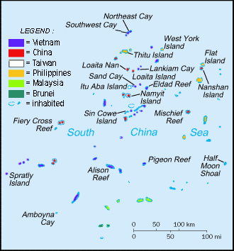
English: Spratly Islands military settlements
Français : Etablissements militaires dans l'archipel des Spratly
Tagalog: Sakop na lupa ng militar sa Pulo ng Kalayaan
中文(简体):南沙群岛的军事区
中文(繁體):南沙群島的軍事區 |
| Agew | |
| Pinanlapuan | Cartothèque Spiridon Manoliu |
| Autor | Spiridon Manoliu |
Licensing
| I, the copyright holder of this work, release this work into the public domain. This applies worldwide. In some countries this may not be legally possible; if so: I grant anyone the right to use this work for any purpose, without any conditions, unless such conditions are required by law. |
File history
Click on a date/time to view the file as it appeared at that time.
| Agew/Oras | Thumbnail | Dimensions | Manguusar | Komento | |
|---|---|---|---|---|---|
| kaplesan | 06:50, 12 Marso 2021 | | 330 × 354 (31 KB) | Mlgc1998 | typo |
| 11:46, 13 Abril 2015 |  | 330 × 354 (18 KB) | RokerHRO | optipng -o7 -i0 → 42.83% decrease | |
| 14:05, 29 Marso 2009 |  | 330 × 354 (32 KB) | Spiridon Ion Cepleanu | {{Information |Description={{en|1=Spratley Islands military settlements}} {{fr|1=Etablissements militaires dans l'archipel des Spratly}} |Source=Cartothèque Spiridon Manoliu |Author=Spiridon Manoliu |Date=March 29, 2009 |Permission= |other_versions= }} |
Saray Gawing
There are no pages that use this file.
Global file usage
The following other wikis use this file:
- Usage on bcl.wikipedia.org
- Usage on br.wikipedia.org
- Usage on cs.wikipedia.org
- Usage on el.wikipedia.org
- Usage on en.wikipedia.org
- Spratly Islands
- Exclusive economic zone
- Republic of Morac-Songhrati-Meads
- East Sea Campaign
- Philippines and the Spratly Islands
- Template:Spratly Islands
- Spratly Islands dispute
- Dangerous Ground (South China Sea)
- List of maritime features in the Spratly Islands
- List of airports in the Spratly Islands
- DK1 rigs
- Great Wall of Sand
- Usage on en.wikinews.org
- Usage on en.wikivoyage.org
- Usage on fa.wikipedia.org
- Usage on fi.wikipedia.org
- Usage on fr.wikipedia.org
- Usage on fr.wiktionary.org
- Usage on gl.wikipedia.org
- Usage on hi.wikipedia.org
- Usage on id.wikipedia.org
- Usage on io.wikipedia.org
- Usage on ja.wikipedia.org
- Usage on ko.wikipedia.org
- Usage on no.wikipedia.org
- Usage on pt.wikipedia.org
- Usage on sv.wikipedia.org
- Usage on th.wikipedia.org
- Usage on tr.wikipedia.org
- Usage on ug.wikipedia.org
- Usage on vi.wikipedia.org